{{tncms-inline content=”<p>Smoke and possibly active flame can be expected to remain present on the fire, however, it is all from the interior. This fire activity will continue to be monitored and poses little threat of spread because it is well within the fireline. Smoke from other fires can also be expected to be visible and present in Emery County as there have been multiple new incidents in the region. For more information regarding these new fires, refer to the Utah fire link posted below.</p> <p>Crews will continue remediation efforts such as dozer line rehabilitation and removal of hose line and other equipment. Over the next several days, Trail Mountain Fire will be demobilizing and reassigning resources as a result of increased containment and the need for resources on other fires.</p> <p>A Red Flag Warning is in effect from today until Wednesday. Under these hot, dry, and windy conditions, fire behavior is more extreme. Recreationists are asked to continue taking fire prevention measures. Please make sure campfires are completely out, and never leave unattended. Remember, lighting fireworks on public lands is illegal.</p>” id=”4eab9b51-df8e-4dc4-8713-cc184a6269b7″ style-type=”update” title=”Updated Information from July 3″ type=”relcontent”}}
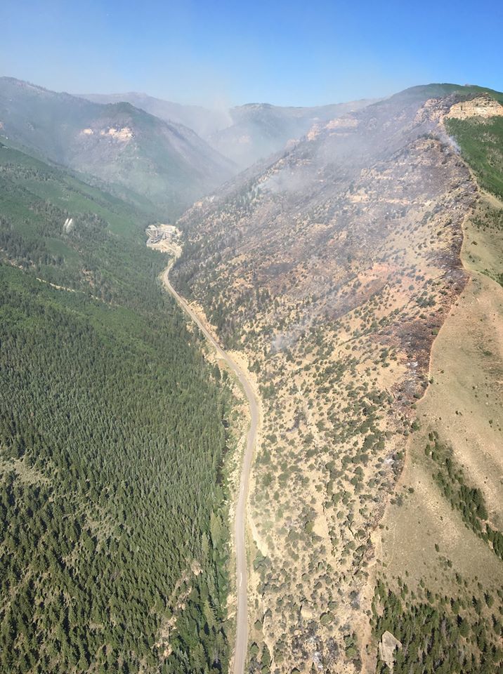
{{tncms-inline content=”<p>Containment efforts continue on the north and east sections of the fire. Fire continues to burn in juniper, sage and conifer but is holding in green aspen. Crews on the west section of the fire continue remediation efforts such as dozer line rehabilitation and removal of hose line and other equipment. Over the next several days, Trail Mountain Fire will be demobilizing and reassigning resources as a result of increased containment and the need for resources at other fires in the west.</p> <p>The Red Flag Warning is no longer in effect, however a fire weather watch is still in effect. Under these hot, dry, and windy conditions, fire behavior is more extreme. Recreationists are asked to continue taking fire prevention measures. Make sure campfires are completely out, never left unattended, and do not light fireworks on any public lands.</p> <p>Current firefighting operations coupled with increased traffic traveling along SR 31 pose greater working and driving risks. To mitigate these hazards, speed limits have been lowered to 35 mph in the canyon where there is the most fire activity. Please use caution. Drivers are requested to watch for these speed limit changes, and follow the posted speed limit at all times.</p> <p>Closures: If you’re planning to recreate in the vicinity this weekend, please be mindful that wildland fires are constantly changing environments. Check fire conditions and closure areas via links below before heading out.</p> <p>The Manti-La Sal National Forest has an area closure in effect around the fire. See a map and description of the area at: https://inciweb.nwcg.gov/incident/maps/5830. Horse Canyon Trailhead, Indian Creek Campground, Little Bear Campground, Lower Little Bear Campground, and Riverside Campsite are closed. Highway 31 is open, but please drive with caution.</p> <p>For More Information: Visit InciWeb at https://inciweb.nwcg.gov/incident/5830/ and Utah Fire Info at https://utahfireinfobox.com/. You can also follow Utah Fire Info on Twitter, https://twitter.com/UtahWildfire, and Facebook, https://www.facebook.com/UtahWildfire/</p>” id=”f066e244-3c90-42e2-a742-f387fd11cacc” style-type=”update” title=”Updated Information from July 1″ type=”relcontent”}}
{{tncms-inline content=”<p>Current firefighting operations coupled with increased traffic traveling along SR 31 pose greater working and driving risks. To mitigate these hazards, speed limits have been lowered to 35 mph in the canyon where there is the most fire activity. Please use caution. Drivers are requested to watch for these speed limit changes, and follow the posted speed limit at all times.</p> <p>Red Flag Warning in effect has been extended through Saturday evening. Weather conditions will be higher than average temperatures, low relative humidity, and gusty, unstable winds. As a result of Red Flag weather conditions, increased fire activity is expected. Check local fire restrictions if you are planning on recreating over the weekend. No fireworks are allowed on public lands. Increased smoke can be anticipated in Emery County as a result of multiple additional fires to the south and west of the Trail Mountain fire.</p> <p>Firefighting tactics have been effective in suppressing the north end of the fire where fire activity is the highest. Fewer helicopter bucket drops have been required to slow spread, and firefighters are now able to directly suppress the fire by cutting line. Continued objectives include containment along the north and east sections of the fire, keeping the fire west of SR 31, and ensuring firefighter and public safety.</p> <p>Closures: If you&rsquo;re planning to recreate in the vicinity this weekend, please be mindful that wildland fires are constantly changing environments. Check fire conditions and closure areas via links below before heading out.</p> <p>The Manti-La Sal National Forest has an area closure in effect around the fire. See a map and description of the area at: https://inciweb.nwcg.gov/incident/maps/5830. Horse Canyon Trailhead, Indian Creek Campground, Little Bear Campground, Lower Little Bear Campground, and Riverside Campsite are closed. Highway 31 is open, but please drive with caution.</p> <p>For More Information: Visit InciWeb at https://inciweb.nwcg.gov/incident/5830/ and Utah Fire Info at https://utahfireinfobox.com/. You can also follow Utah Fire Info on Twitter, https://twitter.com/UtahWildfire, and Facebook, https://www.facebook.com/UtahWildfire/</p>” id=”ed087722-e119-4cc3-9fe3-8d221c023faf” style-type=”update” title=”Updated Information from June 29″ type=”relcontent”}}
{{tncms-inline content=”<p>To mitigate fire operations along SR 31 as well as increased public traffic, there have been speed limit changes (down to 35 mph) implemented. Drivers, please use caution when traveling SR 31, and abide by the speed limit. In addition to following posted speed limits, the public is asked to continue through the canyon without stopping.</p> <p>The Trail Mountain Fire is currently 80% contained, and a Red Flag Warning will be in effect today continuing through Friday. As a result of higher temperatures, lower relative humidity, and gusty, unstable winds, there has been an increase in fire behavior.</p> <p>Recent spotting fire activity on the northeast section of the fire continues to be suppressed and held with helicopter bucket work. Due to shifting and unstable winds, the fire spread involves backing down slopes changing to uphill runs. Fire is currently burning in conifer, juniper, and sagebrush, but is not spreading in live, healthy aspen. Continued objectives include containment along the north and east sections of the fire, keeping the fire west of SR 31, and ensuring firefighter and public safety.</p> <p>Closures: If you’re planning to recreate in the vicinity this weekend, please be mindful that wildland fires are constantly changing environments. Check fire conditions and closure areas via links below before heading out.</p> <p>The Manti-La Sal National Forest has an area closure in effect around the fire. See a map and description of the area at: https://inciweb.nwcg.gov/incident/maps/5830. Horse Canyon Trailhead, Indian Creek Campground, Little Bear Campground, Lower Little Bear Campground, and Riverside Campsite are closed. Highway 31 is open, but please drive with caution.</p> <p>For More Information: Visit InciWeb at https://inciweb.nwcg.gov/incident/5830/ and Utah Fire Info at https://utahfireinfobox.com/. You can also follow Utah Fire Info on Twitter, https://twitter.com/UtahWildfire, and Facebook, https://www.facebook.com/UtahWildfire/</p>” id=”c925e3de-6ead-4182-bdbc-25be9831f836″ style-type=”update” title=”Updated Information from June 28″ type=”relcontent”}}
{{tncms-inline content=”<p>Steep slopes in Huntington Canyon have been a challenge to crews fighting the Trail Mountain Fire and now the Burned Area Emergency Response team (BAER) is looking at the threat these slopes will pose when post-fire rainstorms occur.</p> <p>The slopes, combined with the loss of canopy cover, ground cover, and the formation of water repellent soils, can lead to an increased watershed response to short duration, high intensity precipitation resulting in increased run-off and erosion. Due to physical and chemical changes in burned soils, water collects on the surface of hydrophobic soils, rather than soaking into the ground. Floods and debris flows are the likely result when heavy rain hits the fire damaged slopes.</p> <p>Monday and Tuesday members of the BAER team ventured onto the burned landscape and into the air to begin their assessment. They checked drainages in Huntington Canyon and Cottonwood Canyon. The reconnaissance flight showed the steep slopes, the extent of damage, and deep canyons, which have potential for damaging floods during storms.</p> <p>The BEAR team assesses the risks and works to reduce these threats through appropriate emergency measures to protect human life and safety, property, and critical natural or cultural resources.</p>” id=”bacbcbb2-1cf9-4240-b810-5e7f05ba8c06″ style-type=”update” title=”Updated Information from June 27″ type=”relcontent”}}
{{tncms-inline content=”<p>Summary: Today&rsquo;s weather conditions will consist of hotter temperatures and lower relative humidity than yesterday, and a slight increase in fire activity is expected. Due to successful operations yesterday, the fire is now at 79% containment. Due to overall increased containment and decreased fire activity, the fire management operation has transitioned to the Matheson Type 3 Incident Management team, consisting of multi-agency personnel.</p> <p>Construction of containment line will continue along the east section of the fire. One crew will remain spiked out to continue containment between Little Bear and Mill Fork drainages, and to minimize travel time and exposure when coming off the fireline. Firefighters will continue to secure the north section of the fire with containment line and use of natural barriers such as aspen stands and rocks.</p> <p>In many areas of the fire, mop up and rehabilitation work will continue. The Type 3 Management Team will also be working with cooperators to evaluate powerlines in Meetinghouse Canyon and Elk Springs.</p> <p>Closures: If you&rsquo;re planning to recreate in the vicinity this weekend, please be mindful that wildland fires are constantly changing environments. </p> <p>The Manti-La Sal National Forest has an area closure in effect around the fire. See a map and description of the area at: https://inciweb.nwcg.gov/incident/maps/5830. Horse Canyon Trailhead, Indian Creek Campground, Little Bear Campground, Lower Little Bear Campground, and Riverside Campsite are closed. Highway 31 is open, but please drive with caution</p>” id=”b4533fb6-713c-43e6-b89e-0709386ff0a3″ style-type=”update” title=”Updated Information from June 25″ type=”relcontent”}}
{{tncms-inline content=”<p>A Red Flag Warning for critical fire weather with high temperatures, low relative humidity, and atmospheric instability was in effect yesterday and continues today. These conditions pushed the fire down Crandall Canyon and kept it active in Little Bear Canyon to the south.</p> <p>The fire did not affect the mine and memorial and did not cross Highway 31.</p> <p>It burned across slopes north of the mine but did not burn through thick aspen stands south of the mine.</p> <p>Firefighters worked late into the night in Crandall Canyon and along Highway 31.</p> <p>Pumps and sprinklers ran continuously near the mine and memorial.</p> <p>Late last night, firefighters burned above the Crandall Canyon road and below previously constructed fireline on a ridgeline above the road. The purpose of this burning was to reduce vegetation near the mouth of the canyon to limit spread of the main fire.</p> <p>Today firefighters will take actions near Crandall Canyon and along Highway 31 based on weather, terrain, and fire behavior to continue protecting the mine. Helicopters will be available to support the work of hand crews and fire engines. Their objective is to keep the fire west of Huntington Canyon Road, Highway 31.</p> <p>There was no movement of the fire in other areas, and the fire has been contained along most of the southern, eastern and western boundaries. With Red Flag conditions expected today and Saturday, crews will monitor and patrol the entire fire perimeter. In many areas they will continue rehabilitation to reduce the after-effects of suppression work.</p> <p>Closures: If you&rsquo;re planning to recreate in the vicinity this weekend, please be mindful that wildland fires are constantly changing environments. Check fire conditions and closure areas via links below before heading out.</p> <p>The Manti-La Sal National Forest has an area closure in effect around the fire. See a map and description of the area at: https://inciweb.nwcg.gov/incident/maps/5830. Horse Canyon Trailhead, Indian Creek Campground, Little Bear Campground, Lower Little Bear Campground, and Riverside Campsite are closed. Highway 31 is open, but please drive with caution.</p>” id=”95d74bfa-f2e6-4464-89ba-e0d2c0095c1c” style-type=”update” title=”Updated Information from June 22″ type=”relcontent”}}
{{tncms-inline content=”<p>Thanks to numerous successful containment methods including fireline and burnout operations, the Trail Mountain Fire is now 59% contained. Burning operations above Mill Fork and Crandall Canyon successfully consumed vegetation most susceptible to ignition, removing vegetation that would threaten containment lines if the fire made an uphill run. The Crandall Mine has been properly equipped and protected with sprinkler systems, and the burnout left behind a desirable mosaic pattern of burned areas mixed with unburned aspen and sagebrush.</p> <p>Crews also continue to increase containment and slow fire spread by utilizing green aspen stands, which have high moisture content, and natural barriers such as streams and rocks. These tactics have proven effective in gaining control of the fire.</p> <p>As containment increases, crews will be completing restoration work to minimize any harmful after effects of the fire. Firefighters will be chipping vegetation cut during line construction, rehabilitating dozer line, and clearing streams, roads, and hazardous trees. In areas where erosion is a potential concern, water bars are being constructed to direct water to more stable soil areas.</p> <p>Today a Red Flag Warning is in effect due to increasing winds and low relative humidity. Weather conditions will be hot and dry, with an unstable atmosphere, which can greatly impact fire behavior, making today a critical fire weather day. More mop up and patrolling will take place to eliminate remaining heat. Areas that cannot be accessed by firefighters due to steep, hazardous slopes will continue to be monitored carefully. Crews will continue to diligently secure and patrol the fire’s edge while upholding firefighter and public safety.</p> <p>Closures: The Manti-La Sal National Forest has an area closure in effect around the fire. See a map and description of the area at: https://inciweb.nwcg.gov/incident/maps/5830. Horse Canyon Trailhead, Indian Creek Campground, Little Bear Campground, Lower Little Bear Campground, and Riverside Campsite are closed. Highway 31 is open, but please drive with caution.</p>” id=”4660cfcf-6fe3-4329-a307-d8eba7ab1e73″ style-type=”update” title=”Updated Information from June 21″ type=”relcontent”}}
{{tncms-inline content=”<p>The Trail Mountain Fire is 49% contained. This containment includes most of the southern boundary and sections of the east and west boundaries of the fire. In contained areas crews are patrolling and looking for any remaining hot spots. They are also beginning some remediation work such as removing hazardous trees, clearing roads, chipping cut vegetation, and building structures to manage runoff and sediment.</p> <p>The most recent fire activity has been in the northwest corner near East Mountain Ridge and the head of Mill Fork Canyon. A combination of fireline, intentionally burned areas, natural barriers, and green aspen stands will be used to contain the fire in this area. Crews have built fireline on top of East Mountain and have been burning from this line above Mill Fork and Crandall Canyon. They will continue burning today after careful planning and during times of the day with favorable weather.</p> <p>This burning has created fire that is slowly backing downslope and reducing vegetation available for the main fire. This tactic will prevent the fire from burning more severely and quickly racing uphill which is more difficult and more dangerous for firefighters.</p> <p>Yesterday, two fire engines worked on the Straight Canyon Fire which was detected on Monday. The fire was located northeast of Joes Valley Reservoir, about 4 miles southwest of the Trail Mountain Fire. Last night the engines and crew members returned to work on the Trail Mountain Fire and management of the fire was returned to the Manti-La Sal National Forest.</p> <p>As containment increases, the Incident Management Team is working with cooperators, agencies, and other organizations in the field to facilitate a return to normal business and services.</p> <p>Closures: The Manti-La Sal National Forest has an area closure in effect around the fire. See a map and description of the area at: https://inciweb.nwcg.gov/incident/maps/5830. Horse Canyon Trailhead, Indian Creek Campground, Little Bear Campground, Lower Little Bear Campground, and Riverside Campsite are closed. Highway 31 is open, but please drive with caution.</p>” id=”d8612401-b68a-40b2-9b3d-9d20a1671e65″ style-type=”update” title=”Updated Information from June 20″ type=”relcontent”}}
{{tncms-inline content=”<p>Yesterday on the Trail Mountain Fire, crews worked diligently toward securing and encompassing the fire&rsquo;s edge. Fire containment is now 43%. Firefighters will continue to use natural breaks in terrain and vegetation as well as direct and indirect fireline to increase containment. Burning operations will continue on the west and northwest side of the fire to prevent growth by removing receptive vegetation.</p> <p>Winds coming from the northwest are expected to be less turbulent over the next two days, and temperatures will continue to come down, while relative humidity increases. As fire containment grows, crews will also begin remediation work. Some of this work includes removing hazard trees, clearing roads, clearing streams, and building water bars to help prevent soil erosion.</p> <p>The Incident Management Team also sent firefighting resources to a new fire located northeast of Joes Valley Reservoir, about 4 miles southwest of the Trail Mountain Fire. The Straight Canyon Fire is approximately 2 acres in size. Firefighters expect to contain it by tomorrow. The cause is unknown at this time.</p> <p>Closures: The Manti-La Sal National Forest has an area closure in effect around the fire. See a map and description of the area at: https://inciweb.nwcg.gov/incident/maps/5830. Horse Canyon Trailhead, Indian Creek Campground, Little Bear Campground, Lower Little Bear Campground, and Riverside Campsite are closed. Highway 31 is open, but please drive with caution.</p>” id=”8684ef07-b9fa-4553-b0e4-faf65e3c6021″ style-type=”update” title=”Updated Information from June 19″ type=”relcontent”}}
{{tncms-inline content=”<p>Containment increased to 40% as a result of work done this weekend. Firefighters took advantage of terrain, variations in vegetation types, and favorable weather conditions to build fireline directly along the active fire boundary. This work occurred along most of the southern perimeter of the fire and parts of the eastern and western perimeters. Utility companies will start visiting areas near Meetinghouse and Mill Fork Creeks to assess impacts of the fire on power lines and water sources.</p> <p>Today in areas where the fire is contained, crews will be patrolling and starting some repair work. This work includes:</p> <p>Scattering cut vegetation,</p> <p>Stabilizing soils,</p> <p>Installing water bars to manage water and sediment, and</p> <p>Removing hazardous, fire-weakened trees along roads.</p> <p>Although the northern part of the fire is not contained, crews have been building fireline in safe areas away from the fire boundary. In very specific locations they may do some burning to reduce vegetation adjacent to constructed fireline and limit possible fire growth this week.</p> <p>Today will have warmer and drier weather with increased southerly winds that may increase fire activity. Grasses and other lighter vegetation still contain some moisture from this weekend&rsquo;s weather; however, large conifer trees and other dead vegetation remain dry.</p> <p>Closures: The Manti-La Sal National Forest has an area closure in effect around the fire. See a map and description of the area at: https://inciweb.nwcg.gov/incident/maps/5830. Horse Canyon Trailhead, Indian Creek Campground, Little Bear Campground, Lower Little Bear Campground, and Riverside Campsite are closed. Highway 31 is open, but please drive with caution.</p>” id=”6b8dc419-cffb-4342-bffa-cd0b251546c1″ style-type=”update” title=”Updated Information from June 18″ type=”relcontent”}}
{{tncms-inline content=”<p>Trail Mountain containment reached 40% today after showers Saturday night and a productive day with higher relative humidity Sunday. Relative humidity is expected to decrease with temperatures reaching the mid-70s leading to possible increase in fire activity later in the week. Fire movement currently is decreasing due to containment line in place and lack of receptive fuels.</p> <p>As firefighters work to complete the containment line near the power plant, utility companies will be evaluating possible after effects of the fire in Meetinghouse Canyon, such as sediment issues near water sources. Some sections of the fire are entering the mop up phase, and firefighters will be putting out lingering heat, clearing, and rehabilitating roads.</p> <p>This will be the last evening update unless significant activity occurs.</p> <p>Closures: The Manti-La Sal National Forest has an area closure in effect around the fire. See a map and description of the area at: https://inciweb.nwcg.gov/incident/maps/5830. Horse Canyon Trailhead, Indian Creek Campground, Little Bear Campground, Lower Little Bear Campground, and Riverside Campsite are closed. Highway 31 is open.</p>” id=”186f1626-2f20-4864-9b4c-0745d270d58b” style-type=”update” title=”Updated Information from June 17″ type=”relcontent”}}
{{tncms-inline content=”<p>Yesterday, at approximately 12:00 p.m., Emery County Sheriff&rsquo;s Office and the Utah Highway Patrol closed Highway 31 through Huntington Canyon but it remained open up to Bear Creek Canyon. Increased fire activity had created thick smoke and poor visibility on the highway. Additionally, firefighters and equipment were working directly along the highway. Despite this increased fire activity, evacuations were lifted for the Trail Canyon community. Highway 31 will be constantly monitored today and reopened as soon as conditions allow.</p> <p>Firefighters contained a large portion of the fire perimeter yesterday on the southern portion of the fire near Trail Mountain and Whetstone Creek. The overall percentage of containment does not reflect this containment yet due to fire growth of about 3,000 acres yesterday into Little Bear Canyon and up Mill Fork Canyon. The fire also reached the ridge just south of Crandall Canyon. Firefighters thinned vegetation and installed sprinkler systems around the Crandall Canyon Mine Memorial and adjacent areas.</p> <p>Today&rsquo;s cloudy weather, cooler temperatures, and higher relative humidity should reduce fire activity but will have little effect on the dead and dry vegetation that has allowed the fire spread. Possible thunderstorms could bring gusty winds that would also help the fire spread. On the western side of the fire, firefighters will continue to build and improve containment lines and possibly conduct some burning along Forest Service Road 0145 on East Mountain. On the eastern side of the fire along Highway 31, fire engines will patrol the road and firefighters will continue building containment lines to keep the fire west of the highway. Crews will resume evaluating terrain, vegetation, and weather conditions for opportunities to contain the fire on its northern portion.</p> <p>Closures: The Manti-La Sal National Forest has an area closure in effect around the fire. The Manti-La Sal National Forest closed Indian Creek Campground, Forest Trail 0051, and Forest Roads 0034, 2302, 2181, 2180, and 2182. The campgrounds between the Huntington Power Plant and mile post 18.5 of Highway 31 are also closed.</p>” id=”9c6a14ad-c8ef-4e1b-8d27-ece939bb7f4a” style-type=”update” title=”Updated Information from June 16″ type=”relcontent”}}
{{tncms-inline content=”<p>Fire officials have ordered that SR 31 in Huntington Canyon be closed again due to fire activity close to the road. The closure will be from the turnoff to Rhino Mine up to MP 18.5 which is the turnoff to Miller’s Flat.</p>” id=”713ded92-3b90-4bc7-9304-53f7cd098a78″ style-type=”update” title=”Updated Information June 15 at 12:00 p.m.” type=”relcontent”}}
{{tncms-inline content=”<p>Yesterday&rsquo;s critical weather had a lesser impact on fire activity than fire managers expected. The fire grew just over 1,000 acres, primarily in Mill Fork where it burned against the wind towards East Mountain. Fire spread is more rapid when it burns with the wind rather than against. This moderated fire behavior allowed firefighters to increase containment lines, especially along the western perimeter of the fire. The overall percentage of containment, however, does not reflect this due to the large amount of growth on the fire the previous day.</p> <p>As of 7 AM this morning, Highway 31 has reopened. Firefighters and equipment will continue to work in close proximity to the roadway and there is a likelihood of morning smoke inversions in Huntington Canyon. Please drive slowly through the area and exercise additional caution. Recreation sites along the canyon will remain closed. If at all possible, please avoid driving through the canyon to give plenty of room for firefighters.</p> <p>Scattered dry thunderstorms are possible later today. This may produce gusty outflow winds from thunder cells in and around the fire area. There is also the possibility of new fires starting as a result of dry lighting. Tomorrow, the fire area will see an increased chance of moisture. After that, temperatures will moderate for the coming days, giving firefighters more cooperative conditions for containing the Trail Mountain Fire.</p> <p>Closures: The Manti-La Sal National Forest has closed Indian Creek Campground, Forest Trail 0051, and Forest Roads 0034, 2302, 2181, 2180, and 2182. Trail Canyon and all campgrounds between the Huntington Power Plant and mile post 18.5 of Highway 31 are also closed.</p>” id=”ba123540-2745-46b9-83ea-562023d26c57″ style-type=”update” title=”Updated Information from June 15″ type=”relcontent”}}
{{tncms-inline content=”<p>Due to increasing fire behavior, Emery County Sheriff&rsquo;s Office is closing SR31 from just above the Huntington Power Plant turnoff up to MP18.5 which is the turnoff to Miller&rsquo;s Flat. The power plant is not being shut down. As a precautionary measure, ECSO is evacuating everything between these two points including Rhino Coal Mine and Trail Canyon.</p> <p>More information will follow when available.</p>” id=”a533694b-b654-40c9-bac1-18102337e9d2″ style-type=”update” title=”Updated Information June 13″ type=”relcontent”}}
{{tncms-inline content=”<p>The Trail Mountain Fire grew to 6,497 acres Monday, moving north into Deer Creek Canyon, Rilda Canyon and the plateaus above Mill Fork Canyon, which all feed into Huntington Canyon. The southern and eastern advances of the fire have slowed.</p> <p>Fire crews will be working to keep the fire west of Huntington Canyon (SR-31), north of Straight Canyon, east of Miller&rsquo;s Flat Road and south of Mill Fork Canyon.</p> <p>The fire moved quite slowly Friday and Saturday, but expanded to the southeast after high winds hit the ridgetops Sunday evening. The fire crossed into Meetinghouse Canyon and south to Whetstone Creek where a cabin was burned Monday.</p> <p>The fire is burning in mixed conifer, with large amounts of dead and down timber. It is spotting up to a mile, leaving islands of green aspen and sage untouched</p> <p>Columns of heavy smoke have been visible in local communities and residents have been traveling into Huntington Canyon to get a glimpse of the fire. Officials are asking anyone who does not have a legitimate need to stay away from Huntington Canyon in the interest of public and firefighter safety. Only fire personnel are allowed within the burn area during firefighting operations.</p> <p>The Great Basin Type 2 Incident Management Team 4 will take over the fire Tuesday evening.</p> <p>Officers ask everyone to cooperate with closures in place for the duration of the fire. Indian Creek Campground is temporarily closed. There is a temporary flight restriction over the area of the fire and drones are not allowed over the fire.</p> <p>Temporary closure of Forest Road 0040 (Cottonwood Canyon) has been implemented, as well as the closure of Forest Roads 0034, 2302, 2181, 2180, and 2182. Forest Trail 0051, the Trail Mountain CCC Trail, is also temporarily closed. Closures are ordered for firefighter and public safety. Further closures may occur as necessary. Closures will remain in place until the fire is controlled.</p> <p>-USDA-</p>” id=”9a018934-8848-4137-89f7-3e4b38c803a9″ style-type=”update” title=”Updated Information from June 12″ type=”relcontent”}}
{{tncms-inline content=”<p><em>By Patsy Stoddard</em></p> <p><em>Emery County Progress Editor</em></p> <p>The Trail Mountain fire is no longer under the jurisdiction of the Ferron District Ranger. Darren Olsen opened a fire meeting Monday night where the control of the fire was passed to the Type 2 team, the Great Basin Incident Management Team.</p> <p>Olsen said the fire began as a prescribed burn intended to burn through the heavy fuel loads in the area. The fire started spotting out ahead of itself in the dead and down timber. This caused concern. &ldquo;We appreciate the Type 3 team and the work they&rsquo;ve done as we transition to the Type 2 team. We appreciate the help. These teams are the best at what they do and we appreciate their efforts. This is now a full suppression fire. We are concerned with the public safety and the fire fighters safety. This is a volatile situation with a lot of fuel.&rdquo;</p> <p>Sue Stewart spoke next at the meeting, she is from the regional office and the director of fire aviation. &ldquo;Thank you for being here. You are here because we need you. This is a sensitive situation. This is an unwanted fire. This was a prescribed burn and this is the last outcome that anyone wanted. Be sensitive. There&rsquo;s heartfelt regret about what&rsquo;s happened and it was not intended. We want no injuries or loss of life with our efforts to bring the fire undercontrol. The members of the public are curious.&rdquo;</p> <p>Stewart read excerpts from a letter from the chief&rsquo;s letter of intent. He said to try each day to focus on a working environment with respect and trust and to keep each other safe. The timber is burning like gas and the firefighters were encourage to stay safe. Stop, think, talk and then act. Figure out if there is a better way to do what you&rsquo;re doing.</p> <p>Jason Johnson from the state of Utah said they are anxious to see the fire put out. He is here to lend his support and encourage cooperation.</p> <p>Troy Suwyn said the fire started as a prescribed fire, it&rsquo;s a dry year, but they had the conditions with the correct field moisture, but events happened that pushed the fire out of the border. On June 4 they did a test burn in the field and all went well. The&nbsp; prescribed burn was to take out the mixed conifers to allow aspen growth in the area. Of the 1.2 million acres on the forest there are 400,000 acres of the old timber growth.</p> <p>Troy Suwyn, the FMO, said they felt good about the area selected for the controlled burn. On June 5 they lit areas A and B of the fire. Things looked like they were going well on Tuesday. On Wednesday a spot crossed the line and burned seven acres. On Wednesday they halted the burning. There was a finger of fire in the timber and it spotted from one site to the next and at 8:30 p.m. Wednesday night it jumped the road and went to the top of the hill on East Mountain. The fuel moisture there was 160-162. They expected it would burn and die, but then the winds came.</p> <p>Thursday the fire made it to right below the power line and stopped.</p> <p>Friday and Saturday the firefighters held the line through increasing winds, but Sunday afternoon the winds exceeded 40 mph at 5:30 p.m. the fire crossed the line into a little bowl and made a push. By 7:30 p.m. the weather had cleared enough the aircrafts could fly again. There were four spots at that time and they were one mile out from the original fire. Last night, Sunday night, it burned all night. The terrain in the area is very steep and rocky. The fire is in the mixed conifer. A cabin and some outbuildings have been burned over.</p> <p>In 3.5 hours the fire reached the head of Meetinghouse Canyon and the head of Rilda Canyon. The fire is now down into Deer Creek Canyon. Darrell Cunningham from the Huntington Power Plant told the Emery County Progress they can see the flames from the water intake at the Huntington Plant.</p> <p>He is concerned with the proximity of the fire. He is worried about the health of the power plant workers as the smoke is very thick surrounding the power plant. He is having flashbacks from the Seeley fire which caused numerous problems for the Huntington Power Plant including loss of water quality in the water the plant needs to operate and the flooding and debris that came in the ensuing months after the fire.</p> <p>Russ Bigelow said they are dropping retardant on the fire in Meetinghouse but the fire took off to the south and headed to Deer Creek. There are a lot of fuels in the southern plank. Crews are up there now and want to get the retardant line established again. The utility poles are OK. The fire did burn under them, but they are OK.&nbsp; In the northern corridor the fire is in the middle ridge between the right and left ridges of Rilda Canyon. The power line has been decommissioned and any equipment in Rilda Canyon has been moving out. In the long ridge to the north the fuel is scabby, but at the head of the canyons there are dead Englemann in there.</p> <p>In the section of the fire that is burning near the Mill Canyon bowl, an indirect line of mud has been created to restrict movement there. Any growth to the north on East Mountain has also been restricted and Bigelow said they feel good about that area now.</p> <p>At one point there was intense burning in the Cox Dugway area. The tanks were there and everything looks good there now indicated Bigelow.</p> <p>The air crews have been dropping fire retardant on any threatened structures in the area. Meetinghouse, Rilda and Deer Creek Canyons are now closed to the public.&nbsp; The firefighters are aware of people and structures in Trail Canyon which is the canyon directly across SR-31. They have been warned but aren&rsquo;t in any imminent danger.</p> <p>Heavy equipment has been moved in to help hold the fire lines that have been established. The mud (slurry) is being used to keep the fire from jumping the road at the switchbacks and they will continue with mud down the ridge to try to box the fire in.</p> <p>They are also trying to box off the fire by Deer Creek with the dropping of the slurry right now.</p> <p>Five helicopters have been working on the fire when the wind isn&rsquo;t causing problems. They were grounded most of Sunday. They have been dipping water from Joe&rsquo;s Valley as well as from the water storage containers they call pumpkins. The aircraft were very effective when the winds weren&rsquo;t hampering their efforts. They started their efforts again today with a rotation. There is a short turnaround for the water, so that helps.</p> <div id="tncms-region-article_instory_middle" class="tncms-region hidden-print">&nbsp;</div> <p>The firefighters have been staying on the mountain, but now the operation will be moved to Emery High. The tents will be set-up on the softball fields. The parking will be in the south parking lot.</p> <p>A caterer will set-up there and begin feeding crews at the high school. The first meal there will be on Tuesday evening.</p> <p>Briefings will continue both morning and night for those involved. Crews were instructed to access the fire up Straight Canyon. There have been a couple of near misses on the Cottonwood Creek Road.</p> <p>There were some concerned cattlemen at the meeting requesting access to check on their cattle and haul them water as needed. Darren Olsen, will coordinate with them to make sure the cattle are taken care of properly.</p> <p>Corrinne Dalton reported the fire has cost $935,000 to date and costs will continue to escalate.</p> <p>Brandon Hoffman said with the fire spotting going on, they have had a hard time putting ground crews in. They need a solid plan in place with good communication and leadership.</p> <p>He warned the firefighters the access to SR-29 from the high school has short visibility to see cars coming up the hill. They will work to mitigate this. The firefighters were instructed to watch for deer and elk on the roads leading to the fire.</p> <p>Tim Roide is the incident commander from the Great Basin Incident Management team. He said he looks forward to working with everyone to control this fire. He knows how difficult these situations are. They had a controlled burn escape on his unit and it caused some difficult times. The strategy for this fire is full suppression. There is a big power transmission line and a lot of details to work out. He instructed the firefighters to break into smaller working groups to familiarize themselves with the fire and the plan of attack. A meeting between all the partners involved will take place on Wednesday. Tuesday the Type II team will mobilize. Each planning meeting will discuss the plan and strategy for that next day&rsquo;s operations in the field and will discuss progress made to date on the fire.</p> <p>The smoke from the fire is most heavy in the Huntington area as the winds have pushed the fire into the Huntington Canyon side of the mountain.</p>” id=”74b9b496-5662-42cf-89df-ed9a09f8de22″ style-type=”update” title=”Updated Information from June 11 Evening” type=”relcontent”}}
{{tncms-inline content=”<p><em>By Matt Ward</em></p> <p><em>Sun Advocate Editor</em></p> <p>The Trail Mountain fire moved into Meetinghouse Canyon Sunday after it was hit with wind gusts of up to 55 miles per hour, the U.S. Forest Service reported Monday.</p> <p>Winds grounded all air support and caused the fire to run north and east. The fire has spread to 2,637 acres, and is only 10 percent contained.</p> <p>The fire has created heavy smoke that has been visible from local communities in Emery, Carbon and Sanpete counties.</p> <p>The fire is burning in mixed conifer, with large amounts of dead and down timber. It is spotting up to a mile, leaving islands of green aspen and sage untouched.</p> <p>A cabin was burned in the Whetstone Creek area and other outbuildings in that area are threatened. A high voltage line is in the path of the fire, but has not sustained significant damage. Electricity to the powerline is off.</p> <p>There are 259 personnel assigned to the fire, five helicopters and 11 engines. There is Temporary Flight Restriction over the fire. No drones are allowed on the fire.</p> <p>Only fire personnel are allowed within the burn area during firefighting operations. Officers have asked everyone to cooperate with closures in place for the duration of the fire.</p> <p>Indian Creek Campground is temporarily closed.Temporary closure of Forest Road 0040 (Cottonwood Canyon) has been implemented, as well as the closure of Forest Roads 0034, 2302, 2181, 2180, and 2182. Forest Trail 0051, the Trail Mountain CCC Trail, is also temporarily closed. Closures are ordered for firefighter and public safety. Further closures may occur as necessary. Closures will remain in place until the fire is controlled. Winds from a thunderstorm turned flames from a prescribed burn northwest of Orangeville into a full on wildfire last week.</p> <p>The blaze quickly engulfed 878 acres inside the Manti-La Sal National Forest.</p> <p>What started as a spot burn turned into a wildfire by Wednesday night. And by Thursday the U.S. Forest Service was mobilizing for a full suppression fire on East Mountain. By Friday 208 fire personnel, 12 engines, four helicopters and four air tankers were taking part in the suppression operation.</p> <p>A shift in winds late Thursday likely slowed the fire&rsquo;s advance on East Mountain, moving it toward a previously burned area, according to a forest service press release.</p> <p>The fire had grown from 300 to 878 acres during the day. A high voltage power line was reported to be in the path of the fire. It was shut down with no interruption in services to power customers.</p> <p>Three private cabins on East Mountain were not threatened by the fire by Friday.</p> <p>Two cabins are at least three miles from the fire, and a third is at the south end of East Mountain, not in the path of the fire, the forest service reported.</p> <p>Local residents were told they may see smoke for several days. Forest management officers are asking people to cooperate by staying out of the fire area until it is reopened.</p> <p>A temporary flight restriction order is in place over the fire due to aviation activities in the area. The forest service also announced that any Drones are banned in the airspace above the fire. Flying drones or unmanned aircraft systems within or near wildfires without permission could cause injury or death to firefighters and hamper their ability to manage the fire. There have been incursions from aircraft within the restricted airspace.&nbsp; Officers ask everyone to cooperate with the closure.</p> <p>Only fire personnel are allowed within the burn area during firefighting operations. Indian Creek Campground is temporarily closed. Temporary closure of Forest Road 0040 (Cottonwood Canyon) has been implemented, as well as the closure of Forest Roads 0034, 2302, 2181, 2180, and 2182. Forest Trail 0051, the Trail Mountain CCC Trail is also temporarily closed. Closures are ordered for firefighter and public safety. Further closures may occur as necessary. Closures will remain in place until the fire is controlled.</p>” id=”855b7c7e-2ea5-452e-8296-c101e60f023e” style-type=”update” title=”Updated Information from June 11″ type=”relcontent”}}
{{tncms-inline content=”<p><strong>FERRON, Utah, June 8</strong> —A shift in winds late Thursday at the Trail Mountain Fire may have slowed its advance on East Mountain, moving it toward a previously burned area. The fire had grown from 300 to 878 acres during the day. The fire on East Mountain is being managed as a full suppression fire.</p> <p>The fire, on the Manti-La Sal National Forest, is 15 miles northwest of Orangeville, Utah. It spread to East Mountain when a spot fire from a prescribed burn was hit by high winds during a thunderstorm Wednesday afternoon. The prescribed fire was declared a wildfire Wednesday night and additional crews and resources were brought in to help fight the fire. There are currently 208 personnel on the fire, with 12 engines, four helicopters, and four air tankers.</p> <p>A high voltage power line in the path of the fire has been shut down, though it will not interrupt service for power customers. There are three private cabins on East Mountain which are not threatened by the fire at this time. Two are at least three miles from the fire, a third is at the south end of East Mountain and not in the path of the fire.</p> <p>Local residents will continue to see smoke for several days. Forest Management officers are asking people to cooperate by staying out of the fire area until it is reopened.</p> <p>A temporary flight restriction order is in place over the fire due to aviation activities in the area. Drones are banned in the airspace above the fire. Flying drones or unmanned aircraft systems within or near wildfires without permission could cause injury or death to firefighters and hamper their ability to manage the fire. There have been incursions from aircraft within the restricted airspace. Officers ask everyone to cooperate with the closure.</p> <p>Only fire personnel are allowed within the burn area during firefighting operations. Indian Creek Campground is temporarily closed. Temporary closure of Forest Road 0040 (Cottonwood Canyon) has been implemented, as well as the closure of Forest Roads 0034, 2302, 2181, 2180, and 2182. Forest Trail 0051, the Trail Mountain CCC Trail is also temporarily closed. Closures are ordered for firefighter and public safety. Further closures may occur as necessary. Closures will remain in place until the fire is controlled.</p>” id=”4c2497e2-f409-4b39-a6f2-49a0bafdc8b4″ style-type=”update” title=”Updated Information from June 8″ type=”relcontent”}}
Storm cell moves Trail Mountain Fire out of boundaries
FERRON, Utah, June 7 —An unexpected thunderstorm passing through central Utah Wednesday afternoon spread the Trail Mountain Prescribed Fire across Cottonwood Canyon and onto East Mountain, where about 300 acres have burned. In order to obtain additional interagency firefighting resources, the fire was declared a wildfire. Additional crews, engines and air resources are arriving today, (Thursday).
The prescribed burning has halted. Efforts will now focus on containing the existing fire. Expect containment by Sunday. The spread of the fire has stopped in the green vegetation at the top of the mountain. It is now burning in the beetle-killed mixed conifer.
A temporary flight restriction order is in place over the fire due to aviation activities in the area. Drones are banned in the airspace above the fire. Flying drones or unmanned aircraft systems within or near wildfires without permission could cause injury or death to firefighters and hamper their ability to manage the fire.
Only fire personnel will be allowed within the burn area during firefighting operations. Fire personnel will continue to monitor the burn for its duration. Temporary closure of Forest Road 0040 (Cottonwood Canyon) has been implemented, as well as the closure of Forest Roads 0034, 2302, 2181, 2180, and 2182. Forest Trail 0051, the Trail Mountain CCC Trail is also temporarily closed. Closures are ordered for firefighter and public safety. Further closures may occur as necessary. Closures will remain in place until the fire is controlled.
Red Flag Warning is in effect until Wednesday
Burn Scar