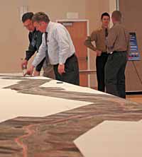
| Myron Lee of UDOT and Bob Jacobs of Stanley Consultants look at a full length aerial map of U.S. 6 during the open house at CEU on Tuesday evening. The meeting was called for citizens to give their input into the supplemental environmental impact statement that was recently released by the transportation agency. |
The Utah Department of Transportation may change planned improvements along approximately 11 miles of U.S. Highway 6.
At a meeting on Tuesday, residents had the chance to comment on an amended environmental impact statement addressing air quality, water quality and wetland concerns.
“We had some input that caused us to look at the plan and to offer some changes that would be more compatible with the environment along the route,” said Myron Lee, UDOT district four representative.
The original EIS contained an alternative for a four-lane highway from Spanish Fork to Green River.
The supplemental plan allows for a variance for two and three lanes of travel on about 11 miles of U.S. 6.
The modifications to the original four-lane plan would affect the following sections of the total 127 mile corridor.
• Crystal Springs area (Spanish Fork water tank) between mileposts 181 and 183 or about 1.9 mile.
In the section, there would be two eastbound lanes and one westbound.
•Skyview area (Tucker rest stop) or 2.5 miles from milepost 201.5 to 204.
There would be one lane in both directions.
•Area north of Soldier Summit from milepost 207.8 to 210 or 2.2 miles.
The highway would have two lanes eastbound and one westbound.
•Area south of Soldier Summit between mileposts 211.3 and 214 or 2.7 miles.
The road would have one eastbound and two westbound lanes.
• White River area from milepost 214 to 215.
The section would have one lane of travel in both directions.
•Area along the White River from 215 to 215.5 or one-half mile.
There would be two eastbound lanes and one westbound.
The number of acres of wetlands affected totaled 16 in the draft environmental impact statement. But under the supplemental EIS, the total would be eight acres.
UDOT collected additional information to determine if increased traffic would cause particulate matter to exceed air quality standards.
Particulate matter is generated by vehicle emissions, blowing dirt and salt that gather in the air near roads.
Emissions at monitoring stations near Interstate 15 in Salt Lake were compared to the projected particulate matter emissions on U.S. 6.
Since conditions on 1-15 with the higher traffic volume did not exceed air quality standards, the study team concluded that the increased traffic on U.S. Highway 6 would not likely exceed standards.
One thing UDOT had faced on federal funding for the road was the fact that, if air quality standards based in the metropolitan part of Utah County in conjunction with the U.S. 6 changes exceeded certain standards, the road could not be widened.
Particulates in Utah County have gone down in the last couple of years and the total will not exceed the federal standards.
Utah regulates the amount of pollutants discharged into the Price River.
Additional water quality analysis by UDOT found that the runoff caused by adding pavement to U.S. 6 would not exceed state regulations.
Citizens attending the open house had the chance to write down comments or give input to an official at the meeting.
Citizens may on the supplemental EIS to UDOT if they do it by March 28. Comments that were made about issues in the original draft EIS are still under consideration so residents do not need to comment on those items again.
After the comment period is over UDOT and it’s planning partners are looking toward later this spring when they will release the final EIS. Then there will be another comment period on that release for about 30 days after that.
Then this summer the Federal Highway Administration will decide on which alternative to implement by signing a record of decision on the final EIS.
Once that has been done, UDOT can then move toward completing the final vision for the road. However, because of funding, that will take a number of years. Most estimate the entire project will take over one billion dollars, and about 20 years to complete.
“The good part of having the Els done is that we will then have a complete vision for the highway,” said Lee. “In the past we have been working on improving the road in sections, in a patchwork manner. Once this EIS is done, when we do those improvements we can make it so the work we do will fit the vision. So instead of a patchwork of various improvements they can all be cut from the same cloth.”