| Instructor Lee Krystinik stands high above the class explaining how the various formations in Castle County aid in aoil and gas exploration. |
There are many pages within the secrets of the Book Cliffs.
Let your imagination roam for a second as we travel to beach front properties, observe great white sandy beaches, watch powerful waves slap against rock outcrops and visualize seas filled with sharks and fishes. Now, snap yourself back to reality, and imagine all this in Carbon and Emery County.
It’s hard to think this could be possible but go back 82 million years and that’s exactly what Castle Country looked liked.
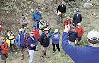
When we think of college classes or advanced technical training we usually think of laboratories or classrooms. While people are familiar with students attending classes in a variety of settings it’s not every day when the classrooms are sandstone formations, sedimentary rock structures, and the deposits of ancient deltas.Geoscentists and engineers from all over the world have been coming to Carbon and Emery counties for years to explore the geological wonders. In September Nautilus USA Geoscience Training Alliance sponsored two week long programs. One group was from Calgary, Alberta representing Burlington Resources, an oil and gas development company working on the eastern front of the Canadian Rocky Mountains. The other oil and gas specialists came from around the country and world; places like Texas, Egypt, the United Kingdom, New Zealand, China, Denver, Australia, Africa and Oklahoma. This is the third time the exclusively Canadian-based field course has studied the archaeological formations of the book cliffs and the coal cliffs. The course is called “High Resolution Sequence Stratigraphy Reservoir Applications.”
Carbon and Emery counties offer world class opportunities for geologists to understand the science of drilling. Simply put, it means that geologists take the professional skills they have learned in the past and bring them to this area where the formations can assist in understanding how to predict depths, gather data, and determine where the gas and oil can be found.
“Being able to walk on it, see the layers or rock as they have developed makes a big difference,” say instructors Andy Pulham and Lee Krystinik. They show the students first hand how one layer connects to another and thus where gas or oil is most likely to be found. “Rocks are holding back secrets,” says Krystinik.
| Instructors Andy Pulham and Lee Krystinik show a map of the Spring Canyon area which indicates the depths of sand, former deltas and possible gas deposits. |
“The roots of this training extend back to 2001 when we made a commitment to the Geoscience Training Alliance companies to raise their technical bar,” explains Krystinik. The course provides an opportunity to practice shared earth modeling at a variety of locations along the Book Cliffs in Carbon and Emery County. “Here in Utah we’ve brought geologists, geophysicists and engineers from each of Burlington Resources’ four divisions together to jointly interpret and discuss the complex relationship between reservoir and non reservoir rocks.”
The Cretaceous strata of the Book Cliffs and Coal Cliffs of Southeast Utah are one of the world’s premier resources for the study and understanding of high resolution sequence stratigraphy. Numerous stratigraphic research projects have been conducted in the Book Cliffs and Coal Cliffs over the past 30 years.
The attraction of these field localities to researchers and students of geology alike include an unsurpassed opportunity to study the internal characteristics and stratigraphic architecture of a variety of deposited systems from continental to shallow marine environments, Study of the Book Cliffs by Exxon researchers in the 1980s.
Training focused in coastal near shore and shelf settings that are common components of delta and shallow marine.
The Book Cliffs have long been used for the study of sub surface, reservoir related issues. The Coal Cliffs have attracted equally numerous reservoir related research projects currently one of the key areas in the United States for coal bed methane production.
The Ferron Sandstone has been studied extensively since the early 1980s. The excellent outcrops have prompted many oil and gas industry analog studies which have included the drilling of behind outcrop wells.
While traipsing through the cliffs and canyons the geologists and gas experts were determining trends and patterns, observing marine shale, looking for basins, shores, sands formations, and speculating where the rivers, beaches, fields, coastal planes, and deposits could be located.
“Collectively this is the best interpretation we have seen,” says Pulham.