In 1933, a report was released by the chief engineer of the Utah State Road Commission, H.S. Kerr, regarding projects that had been completed and the funds expended from 1922 to 1932.
In the early 1920s, the Midland Trail or the road from Spanish Fork to the Colorado line became part of the U.S. highway system. It became U.S. Highway 50. That designation by the United States Congress was more for political reasons, but in years to come would have a big effect on what happened with the road that ran through eastern Utah.
During the time the report covered, little federal money was available for highway construction, even though the 1920s were a boom time in the United States. When the Depression hit in 1929, prospects for improving the road even looked worse.
Kerr, however, pointed out that quite a bit of money had been spent on the highway. Twenty-seven projects had taken place between Spanish Fork and the Colorado line, costing $3,051,395.93. In Carbon County, projects during the 10-year period had cost $1,305,062.19.
The larger figure was to work on and improve more than 200 miles of road. By comparison today, it costs $1 million to put one lane of road for one mile through mountainous areas and about $600,000 per mile in flat areas.
Most of that $3 million plus was for gravel and the labor to put it down; little was for pavement.
When the Depression hit in 1929, the money got tighter. But in the summer of 1934, things began to change. President Franklin Roosevelt’s National Recovery Act (NRA) was beginning to take effect and money was becoming available to employ local workers on public works projects. One of the projects was U.S. 50 in eastern Utah.
In 1934, a contract allowed improvement to the road from Price to the Colorado line. Under the teams of the project, much of the road would be regraded and graveled, but some sections would receive a hard surface treatment, which consisted of gravel and oil. The project would cost about $95,000.
A section of road that had been prone to washouts and damage would receive the bulk of the hard surface – the 34 miles between the Carbon County line and Green River. The stretch had been a problem for travelers with its damaged surface and thunderstorm damaged crossings over washes.
During the 1920s, the only piece of road that had received concrete was a strip of the highway from Castle Gate up the canyon 2.18 miles to the old railroad stop of Rolapp. Other than that, all the projects had only been gravel. But roads weren’t the only problem.
Locals complain today of the danger of U.S. 6, but a quick glance through the Sun Advocates front pages of the 1930’s will bring anyone to earth about modern fatality figures. While cars were generally not as powerful, and large trucks were the size of what most local delivery vans are today, the death toll on the highway was much higher. In fact hardly a week of time would go by that some incident involving a death on the highway wasn’t reported.
Cars at the time didn’t have seatbelts or airbags. There were no padded dashes or even true safety inspections. Almost anything could be driven on the road and the licensing of drivers was not very strict. Safety was totally up to the driver and others that were driving toward him. A car that ran off the road and over turned often resulted in death; two cars crashing head on above thirty miles per hour was almost a sure trip to the morgue.
Incidents in 1933 included a young boy who jumped off a hay wagon on U.S. 50 in Carbonville and ran across the road. He was hit by a driver from Helper and killed immediately.
Another incident a week later left a young lady from Carbonville dead when the car she was riding in through the Wellington area left the road and turned over in a wash. The young man driving was trying to talk to some friends in the back seat and moved the wheel when he turned to speak to them.
In another incident a high speed crash took place when a man and his wife from Wellington were headed toward Woodside to visit some relatives who lived there. A few miles from the town (in those days there were no mile markers) the car left the road after it crossed a wash too hard and the driver was thrown from the car killing him.
This final incident showed the condition of the road between where the Horse Canyon cutoff exists today and Green River in the early 1930’s.
Today that area is still dangerous and still registers many deaths, but the causes are somewhat different. While fifty miles per hour on a dirt and gravel road may be excessive, today’s drivers regularly exceed the 65 mph limit on this stretch of road by twenty or even thirty miles per hour.
The roads actual surface is now much better than in the middle of the depression, but the rises and falls and the long stretches of straightaway that seem to go on forever still exist.
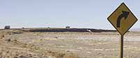
As a driver leaves the mesa where the Horse Canyon cutoff is located, the vehicle heads down a steep down hill where a sign is posted that says “Possible crosswinds next 1/2 mile 50 MPH.” These winds, while seldom dangerous for most cars can be deadly for large trucks and motorhomes. No deaths occurred from 1996 through 2000 in this area, but vehicles have ended up on their side on this stretch of road due to winds.
The road through this area is a straight shot with some hills and rises from mileposts 270 to 275. Just past 275 the road begins to rise to crest a hill. Just past this point, anxious drivers coming from both directions sometimes try to pass, although they can’t see as far as they could have father down the road. An accident in 2000 took a life at milepost 275.09. Only a mile away at 276.15 another fatal occurred in 1999.
Once past this hill drivers are bound for Woodside, a once thriving gas stop that seems to come to life every few years, stick around for awhile and then close again.
From here until past milepost 287 the road is deceptively straight. It seems a driver can see for miles and in some cases they can, but it is also a place where high speed becomes even higher, particularly for those traveling north and going down hill. In 1997 this stretch was marred by a bad fatal crash at milepost 282.25.
But the worst stretch of this road for death is yet to come. And it all seems to center around the railroad overpass from about 286 to just past 288. It’s hard to say why, but that stretch with it’s wide curves and many warning signs seems to sneak up on drivers. Or maybe the drivers just sneak up on it. Nonetheless fatal accidents in the area occurred at 286.77 and 288.07 in 2000 and 287.77 in 1997.
While the few miles of the road left before reaching I-70 is similar in most ways to that on the other side of the overpass, no fatals occurred during the late nineties in that area.
U.S. 6 between Spanish Fork and Green River is considered one of the ten most dangerous highways in the United States. The death toll in the five year period from 1996-2000 neared 100 and for a road that is not considered “major” that is a lot of death. Yet the traffic on the highway continues to increase, and in fact the traffic rate on U.S. 6 is higher than many it is on many interstates. Time will change the highway, just as it has in the past. Where those changes lead the people of Carbon County remains to be seen.
On the spot safety can only be determined by drivers and how they control their vehicles. No amount of road design change can stop someone from speeding or making bad decisions.
Tracking U.S. 6 from Price to Green River