A crayon and a drone marked the start of Wellington’s response to two floods in the past three years.
Bart Jensen, project manager at Jones & DeMille Engineering, used the colored wax to describe brainstorming via sketches on a map of Wellington about how to resolve the issues presented by early-fall floods in 2014 and 2016. And the company, which is contracting with Wellington City after the municipality did not qualify for funds from the Federal Emergency Management Agency, deployed a new-model drone to assess the area.
That includes the bridge over Price River and near the railroad east of town. Because the water passageway beneath it gets clogged, “it’s like a hairball in a shower,” Jensen said.
Jensen expressed the metaphors at a public meeting hosted by the City and the Price River Water Improvement District, where residents also heard from United States Department of Agriculture staff, Jensen, three of his colleagues on the project and Mayor Joan Powell. A Flash Flood Watch for two-thirds of Utah, including Wellington and Carbon County, was advised a day-and-a-half after the meeting.
Drones have been in the civil engineering industry for a decade, Jensen said, but his company’s model is a new one.
“The data we get from the drone not only helps us with this model, but now, we take it and with our design software, we know what the surface of the ground is doing,” Jensen told the Sun Advocate. “So when we draw a berm in, we know how far it’s going to go out; how tall it will be at a particular spot. We use that in our design and quantities.”
A berm lies flat between a fortification and a ditch to keep out water.
One of nearly two dozen meeting attendees included Mark Pickup, who reportedly has the closest house to the river. Another asked if the firm’s initial considerations would mean for no flood this year.
“The flood would not be as bad,” Jensen said.
Another asked if it would make flood insurance unnecessary.
“That would be a different study,” said Ricky Andersen, one of the other engineers.
“But this study is the first step,” Jensen added.
Only a few residents, including meeting attendee Matt Moss, had flood insurance at the time of the disasters, resident Rhea Branch told the Sun Advocate.
A third asked if the firm had modeled what the area floodplain would look like if the clog was addressed.
“With no berms,” she added.
After saying it hadn’t – though a berm, already put in place after the 2014 flood, is being reinforced behind near-$1 million funding – Andersen added that the firm wanted to prepare for the “worst-case scenario,” including designing for new vegetation. The engineers talked at many points throughout the 1-hour, 45-minute meeting about replacing invasive species like the Russian olive tree with native species “that will lead to improved flow,” said Parker Vercimak, a graduate engineer.
Branch added that three of the 11 homes damaged in the 2014 flood have been torn down and described her house as being in a “hole” beneath the bridge clog, though she believes the firm’s outlook will lead to an improved situation for her.
Tony Beals is an emergency watershed program resource conservationist for the Natural Resources Conservation Service, a division of the USDA. He said that Justin Needles, the emergency manager for Carbon County, sought for the jurisdiction to qualify for a “presidential declaration” that would have meant for assistance from FEMA, which has helped with disasters including Hurricane Katrina in 2005.
“They didn’t rise to (that) level,” Beals said after emphasizing: “Under the EWP program, we let a local facilitator do it.”
NRCS granted $1.9 million to Wellington in May after giving Helper and Carbon Canal $4.2 million in June of last year. NRCS is paying 75 percent of the construction cost, with the other 25 percent needing to come from local services.
NRCS will review Jones & DeMille’s proposal.
“This is an important first step,” Beals said after Jensen’s crayon reference. “It is needed before (a cultural appropriation agency) and the (Bureau of Land Management) can get involved.”
Jensen, after saying that the research of his team and the drone is a “large portion” of the overall project, outlined reasons to the Sun Advocate for the bridge clog. He noted that while many bridges have piers only on their ends, the railroad bridge has piers throughout the middle, too, so things get stuck in it easier. And it’s rather low to the river, so you can’t get as much water and debris through it without getting the physical impasse, he added, saying also that the railroad had cleaned some of the debris out of the “log jams” that got stuck in the bridge.
“That’s kind of a bottleneck area,” he said. “(The bridge) isn’t a clear-span bridge; it doesn’t go clear across.”
In September of last year, 2.81 inches of rain hit the Price Airport during a 72-year period, according to the National Weather Service. It was described as a thousand year event – and the other floods in Aug. and Sept. 2014 were similar, when about three-quarters of an inch fell within 20 minutes and 100 homes and businesses suffered flood damage. In the second flood, the PRWID Waste Water Treatment Plant in Wellington kept running due to flood mediation improvements made after the first.
Airborne ‘eyes’ aid Wellington flood control design
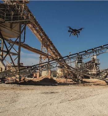
A drone surveys an unspecified location. The model was used by Jones & DeMille Engineering for the firm's outlook on managing recent floods for Wellington City. 3D Robotics