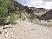
| Abandoned in 1966, segments of the old highway still stand on the hillside in Price Canyon. Trees break through the pavement and rocks cover the surface in several spots, while the road is eroded away at other places. Although only 40 years old, the ‘new’ highway has seen vast changes, including a major leap in the amount of traffic the road carries on a daily basis. The four-lane design of the early 1960s gave way to a two-three lane design due to budget constraints. The three-lane sections, heralded at the road’s dedication, have become a major point of ongoing criticism. |
The highway that passes through Price Canyon has had many incarnations; officially three, unofficially probably more.
The path that generated into one of the heaviest travelled non-Wasatch Front roads in Utah began as a foot trail along the river that was eventually replaced with railroad tracks.
Not long after the tracks came a dirt road was cut high up along the canyon walls; the road that was part of the Midland Trail.
In 1913, the canyon road opened to acclaim as the fastest and safest route to Salt Lake City from points in southeast Utah and for motorists traveling across the country.
From 1927-32, vast changes were made to the canyon road, including the tunnel that was bored through where the cut by the power plant is now located.
The new route, was claimed to be faster and safer.
While the construction during the time was relatively minor in nature (with the exception of boring of the tunnel), the projects did improve the road. But the effect of the depression that began in 1929, influenced what was spent, and therefore some plans were left uncompleted.
Many of the plans had to wait until the money and the technology were available to make the road a better place to drive for the masses of vehicles that were to use the highway over the years.
In July 1966, the ribbon was cut by Gov. Calvin Rampton and the new road was officially unveiled after almost two years of work and a cost of $5 million. Costs were later estimated at closer to $7 million.
The road was still known as U.S. Highway 6-50, a designation it would lose when the interstate system on both ends of Utah were completed.
When Rampton cut the ribbon, the road had actually been open for about three weeks. But on the day in July, the road was closed until the ribbon cutting, with the Utah Highway Patrol routing motorists through the detour built to handle traffic during construction.
Willow Creek Canyon and Kyune Pass were the main route. During the years, the road would be used for moving traffic out of the canyon; both because of accidents and other construction that has taken place since.
The dedication ceremony was sparsely attended. Pundits said the opening was merely a formality since Carbon and Emery residents were already used to the new highway they had been driving for almost a month.
But the three major incarnations of the highway were still visible in the canyon in 1966.
State engineers, standing on a hill near the Kyune Pass cutoff, took a picture of the canyon as it starts the initial descent into the Castle Valley.
The photo shows the thoroughfare used by motorists today, the recently discarded road located four stories higher up on the canyon wall, the 1966 highway and a slight indentation of the original Midland Trail.
The indentation is located high above the 1932 road.
Several times during the ceremony, Rio Grande trains moved up the canyon disturbing the festivities. The loud roar of multiple diesel-electric engines was a little much for the less than 100 people gathered to hear the program.
Some reports, however, listed the attendance at 300 individuals.
Rampton related to the audience that he had some personal experience with the old road, much more than just driving it.
| Engineers capture a picture of Price Canyon shortly before U.S. 6 opened in the mid-1960s. On the lowest level are the railroad tracks and the Price River. Next is the ‘new’ highway opened in 1966. Higher up the grade of the mountain is the road completed in 1932. The Midland Trail is at the top, barely visible. |
It seems after World War II, the governor had purchased a home in Dragerton (now East Carbon) and planned to move the structure to Salt Lake.
Problem was, the house would not fit through the tunnel at Castle Gate.
The moving crew ended up transporting the structure over Indian Canyon instead.
It probably would have been easier to enlarge the tunnel than moving the structure along the route the crew had taken, quipped Rampton.
According to news reports published in 1966, the creation of the new highway represented an engineering marvel that would solve many traffic-related problems that the canyon had faced for years.
But all of that came at a cost. And the costs were not restricted to dollars only, the project having been one of the most expensive for basically a two-lane highway ever done in the state.
Many people in the local community were upset by the fact that the actual Castle Gate rock formation had to be drastically cut back to accommodate the new highway.
Little did people realize that, in subsequent years – particularly in the early 1990s, the formation would be altered further due to a number of incidents, some fatal accidents, caused by rocks falling from the cliff.
Other local residents were concerned about the loss of Royal, a small mining community that was basically wiped out to build the highway.
The result, however, was a better and safer road.
Deaths and accidents in the actual canyon had never been high, considering the extreme circumstances that drivers sometimes faced.
But the number of mishaps were initially reduced dramatically when the highway opened.
In subsequent years, however, death tolls have started to rise.
According to state officials, the situation is primarily due to the dual headed monster of traffic exceeding the volume the highway was built to handle in 1966 and higher speeds.
The existing conditions were also somewhat brought on by the highway becoming a connection between Utah’s two major interstates.
The “three lane” configuration of the new highway was heralded by the Sun Advocate at the time.
The Carbon County newspaper proclaimed that “no difficulty is experienced in passing slow moving vehicles.”
Engineers had originally planned a four-lane road all the way through the project’s geographical limits.
Then as the budget reality of blasting away more cliffs set in, the engineers reduced the size of the road to three lanes in some areas and two in others.
The highway Carbon County motorists continue to travel was built at a time when there was one vehicle for every three people in the United States.
Today, there are enough for all Americans to have a vehicle to drive.
Traffic volumes have increased dramatically on the canyon highway since the coming of Interstate 70.
In fact, the traffic counts on U.S. 6 in Price Canyon often exceed I-70 totals on a per day basis.
During the last 20 years, numerous improvements have been made to the road and continue to be made.
While not directly in Price Canyon, the latest project will widen the road between mileposts 196-200 in an area that has been prone to accidents.
The improvement project involves several stretches of U.S. Highway 6 that cause drivers to become impatient, often affecting other sections down the line.