It’s been several years since I floated the Price River from Woodside to the confluence with the Green River, but it was an amazing experience.
Some years it’s almost impossible to float this section of the Price River due to lack of water, including this year. To catch a high water event after a storm is very difficult and can be dangerous. High water brings debris, which can cause blockages and hazards.
Hard-shell kayakers have a distinct advantage over inflatable kayakers, because inflatables are less maneuverable and much more vulnerable to the flows of the river.
Several years ago I was able to float the river twice with my son Bo.
Thane Allred joined us on the second trip. This article is about the second trip.
We had almost twice as much water as we did on the first trip. Usually this section is runnable only when Scofield Dam is releasing more than the minimum amount of water required. Most of the water after April is diverted for irrigation.
It is a great kayak or inflatable kayak (IK) trip.
Carbon County Recreation rents IKs. The only problem is that people coming from the east would have to backtrack to return a rental.
For people coming from the Wasatch Front, it’s the easiest pick up and return you’ll ever have.
The most significant rapid on the river was only created in 2005 by a rock fall. That’s seconds in geologic time.
It was named BoS Rapid, by Shane Rasmussen. The acronym stands for something I’m not comfortable writing here. It is a serious class 4 rapid. It is about four miles (I’m guessing) from the confluence.
There are no significant rapids below BoS. At BoS there are two large rocks in the middle of the river. Below the rocks are smaller rocks that create three slots.
The right slot is clogged with debris and is a death trap. At low water you must go around the second big rock on the right, catch the eddy below and then get left.
The left and middle slots are runnable, or at least were when we were there. You must scout this rapid. Get over on the left above the initial house-size rock. Don’t even attempt this rapid if you are not a competent class 4 boater.
A portage is not admitting defeat. Okay, that’s my disclaimer. I will not be responsible for someone dying in the right slot.
After scouting, Bo, in a hard-shell kayak, had a perfect run. He entered right of the large rock, caught the eddy below, and easily made it to the left side.
Thane had a bit of a problem and ended up wet-exiting his kayak when he flipped on the middle rock.
He floated through the drop and Bo helped him get out of the river and back to his kayak.
After Thane’s issue, since I was paddling an inflatable, I decided to go all the way to the left bank. I figured a mistake over there was less likely to be disastrous than on the right.
I can’t emphasize enough the danger of the right slot.
My intention was to stay left and take my chances over there. As I passed the lower big rock, the flow was pushing me right. I realized the flow was too great and I would not be able to make the left slot. So, I paddled hard to the right and made it to the middle slot. It wasn’t the prettiest run, but I made it.
Gary Nichols’ book River Runners Guide to Utah has some information about the river, but nothing about BoS, since his book came out before the rapid was created.
Above BoS are numerous class 3 moves. A lot of awesome short drops and fun slots. Plan for a long day.
It’s 25 miles from Woodside to the confluence, then another 5-plus miles to Swasey’s Beach, the common take out.
There is an alternate take-out at Butler Wash. It is just below the confluence and cuts five miles off the trip.
Think about shuttling your vehicle there. It can be a gruesome five miles to Swasey’s when the wind comes up and you’re already tired.
You can shorten the trip a few miles by driving down the road from Woodside. That also is not a bad idea, just adds time to the shuttle.
Price River Run
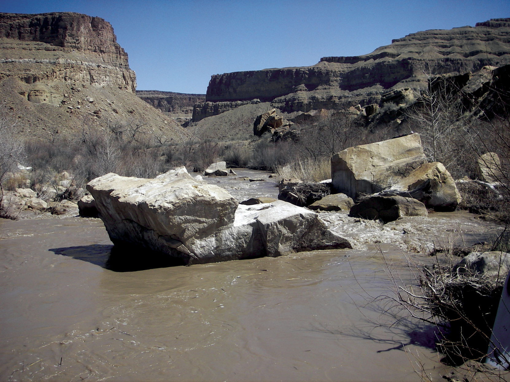
#1 The approachWhen you see the house-size rock in the middle of the river you need to get left immediately in order to scout the rapid from the left bank. Get out of the river well above the big rock.