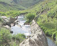
| Rubble still sits in Fish Creek from the collapse of the Mammoth Dam in 1918. There are other dams in the area, including the little Gooseberry Dam just above where the Mammoth Dam once stood and at Fairview Lakes. But the Gooseberry Narrows project would provide the largest dam on Fish Creek and its construction is being disputed by a number of parties, including Carbon County water interests and the Utah Rivers Council. |
The plans to build a dam across Fish Creek in the Gooseberry Narrows ran into more organized opposition in late October when the Utah Rivers Council released a report suggesting five alternatives for water supplies in Sanpete County.
“Why the Bureau of Reclamation would spend so many dollars on a dinosaur like this project instead of putting the money into more progressive programs that are less costly and more efficient is what we are wondering,” said Amy Defresse of the Utah Rivers Council on Monday afternoon. “We just think they should fund projects that are better.”
For more than 100 years, the idea of building a dam to give more water to Sanpete County from the Fish Creek drainage has had one incarnation or another.
But disputes between interests in Carbon County, where the water naturally flows to, and Sanpete County, where a lot of the snow melting into the drainage falls during the winter, have marked the ongoing battle decade after decade.
“The Gooseberry Narrows dam project is a remnant of that era when federal dollars funded costly projects to develop water resources in the arid west where precipitation is an unreliable source of irrigation water,” stated the report’s executive summary.
“Today, we recognize that society can no longer afford these projects and we have learned that the benefits do not outweigh the economic and ecological costs. In this new era of rethinking water development in the west, it is critical that we consider all available options before repeating the mistakes of the past,”continued the council’s report
The development of water along Fish Creek came early when the first settlers arrived in the Sanpete Valley in the mid-1800s.
The pioneers diverted water from the Wasatch Plateau for use in the Sanpete area.
Fairview Lakes were created and water was sent from the development through a tunnel into the populated areas of Sanpete County.
As World War I was beginning, Carbon water interests built the Mammoth dam in Sanpete County.
But in spring 1918 before the reservoir could be completely filled, the dam collapsed and rushing water downstream caused major damage in Castle Gate and Helper.
In the 1920s, the first Scofield Dam was built to block water coming from Fish Creek and Muddy Creek.
The first dam at Scofield was later declared unsafe and water levels in the lake were kept low because of the structural problems.
In the 1940s, the second Scofield Dam was built with federal help.
The second dam at Scofield still stands on the creek.
Scofield Reservoir is the main water supply for most of Carbon County for agricultural and municipal use.
At times during the last century, the Gooseberry Narrows dam project has been resurrected and summarily dismissed time and time again.
Today, the proposed project is still up in the air with the added complications of environmental and sportsman’s groups taking sides on the issues.
In recent years, settlements were drawn up that agreed on what water belonged to Sanpete County and what belonged to Carbon County.
However, the diversion of water and the measurements of the diversions have been in question.
The Utah River Council report suggests five recommendations for improving water use and conservation in Sanpete County as an alternative to a new dam estimated to cost at least $25 million to construct.
The recommendations include:
•The municipalities of Fairview, Moroni, Mount Pleasant and Spring City should establish a water conservation goal representative of the climate in northern Sanpete County and cognizant of existing higher than average non-potable water use rates.
The goal should outline a 40 percent reduction in nonpotable water use by the year 2050 (1,590 acre-feet/year).
•Suppliers of non-potable water in northern Sanpete County should install meters to measure non-potable water use, encouraging its conservation.
• Water irrigation companies and municipalities who distribute non-potable water should develop a conservation-based water rate structure for secondary water that represents the value of water in a climate that receives eight inches of rain per year.
•Irrigation companies in Sanpete County should implement water conservation projects and water storage projects in order to alleviate late season irrigation shortages in northern Sanpete County.
• Federal and state agencies financially supporting the construction of the Narrows project should evaluate how the funds can be redirected toward the implementation of alternatives.
In addition to the recommendations, there are many different types of specific alternatives that go along with the Sanpete County entities following some of the suggestions.
Water conservation measures that the council suggested include installing meters on secondary water systems, rehabilitating the present delivery tunnel, installing sediment traps, replacing open ditches and canals with pipe, installing pressurized systems for sprinkling rather than flood irrigation and extending existing piped systems that already exist.
The report suggests that the Sanpete area could use a number of small dams and water repositories in the present drainage to conserve and save water for agricultural lands in the later summer and early fall, a problem that users of water in the area face almost every growing season.
To support the recommendation, the river council report pointed to a study done by Franson-Noble and Associates from July of 1996 that listed 10 sites for potential dams within northern Sanpete County.