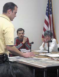
| A representative of Jones and DeMille Engineering presents East Carbon City councilmembers with proposed routes for consideration through the locality. Councilmembers have been asked to pass a resolution to define approved routes for off-highway and other traffic through the city. |
Councilmembers in East Carbon reviewed the city’s involvement in the county’s proposed cross country trail on Tuesday.
The review process is in line with other communities in the county regarding involvement in the proposed trail system.
Last fall, the Carbon County Commission awarded the bid to construct a trail system that would span from Skyline Drive to Nine Mile Canyon to Jones and DeMille Engineering out of Richfield.
The proposed trail passes through Scofield and Helper and connects to Wellington and Price by way of spurs into the two largest cities in the community.
As county planning staff and project engineers finalize the routes through and between cities, they have contacted the various municipalities to review what route local governments favor.
In the case of Helper and Scofield, the routes were designated before the bids were awarded.
County planning director Dave Levanger said he believed Sunnyside officials had already passed an ordinance to designate a trail through the local community.
East Carbon was the only city that the trail will pass through where local officials had not passed such an ordinance, said Levanger.
The trail system had a proposed route through East Carbon already in place, but that it was a purely tentative route, added the county’s planning director.
The county’s planning director explained that each city would define its route.
Mayor Orlando LaFontaine said he had spoken with engineers and county planning staff and favored a route that entered the city on the northwest.
LaFontaine and Levanger both supported a route that crosses Grassy Trail Creek near the golf course and stays away from residential areas.
By staying away from homes, noise levels will be reduced and the trail users will be directed closer to local businesses.
The council noted that there has been some discussion about creating a trail along the rail line. The mayor indicated that the owner of the rail line had approached him and was amenable to a proposal to convert the rail line to part of a trail system. While it was not finalized whether the rail line will be used for ATV traffic of if the transaction will actually take place, it was suggested as one option to consider in planning the route.
Legvanger said that the trail system will do more than attract visitors to the area. He said one of the positive benefits of the trail system will be the economic impact on local communities. He pointed out that many riders will wtop in communities such as East Carbon along the route to purchase gas and food. Others will spend more at hotels and restaurants in larger communities.
He noted that the target demographic of trail systems of this kind primarily consists of retired individuals, who are more likely to spend more than younger groups.
The proposed trail system is a multi-use trail that will accommodate ATV riders, equestrian traffic and other groups. From East Carbon and Sunnyside, the proposed route climbs to Bruin Point and then takes a loop down Dry Canyon to Nine Mile Canyon and then up Cottonwood Canyon to Bruin Point.
In order to facilitate that route, the county will have to open approximately 2.5 miles of nine Mile Canyon Road to OHV use. However, Levanger said the rest of the canyon road remains closed to OHV traffic.
Councilmembers pointed out that many OHV riders travel outside those boundaries. Levanger said that was a matter of enforcement. He further added that by defining an established trail system, the county and local cities can regulate OHV traffic more easily and cite individuals that travel outside the approved routes.
The county planning director explained that the city would have little financial obligation in creating the trail system. He said the only participation required of cities would be to pass ordinances that establish the routes through their municipalities.
The trail system has the backing of local OHV enthusiast groups. In addition, the county small business alliance and other economic groups are on board, said Levanger. Primary funding sources include the Carbon County Recreation and Transportation Special Service District and the county’s restaurant tax fund.
The trail is expected to be established and ready to use as early as this fall. However, improvements to the system, including kiosks with maps, garbage collection and restroom facilities are not expected to be in place until fall 2007.
Councilmembers voiced their support of the trail system, with some concerns about the final route.
“We are excited and we want it,” said councilmember Darlene Kuhns. However, others had reservations that needed to be resolved before they could fully support the concept. Councilmember David Maggio said his biggest concern was the crossing of Grassy Trail Creek. He emphasized the need to accommodate the higher levels of water that sometimes fill the creek well beyond its normal level.
A representative of Jones and Demille said the engineering firm would begin working on plans for the route the next day and would present those plans to the city for approval at a later date.

