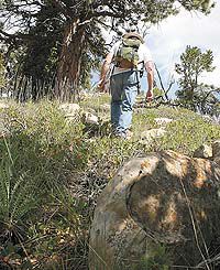
| A hiker makes his way toward the upper part of the Price Recreation Area nature trail. The trail spans an area that goes from the campground to the upper reaches of the ridges in the area. Presently the trail is being revamped by the BLM. |
Camping, and even going hiking can be a complicated affair.
Getting all the equipment together, making sure everything is there and operational, checking out the vehicles and gassing them up, loading up food and beverages and getting it all in the car to go.
And then there is the long trip to wherever the long awaited destination exists.
The after a tiring day or weekend of having fun there is the long trek home and all the cleanup that goes with it.
Simplifying the process would be something most people would like to do.
Well if one lives in Carbon County two of those steps can be nearly eliminated because of great recreational opportunities within just a few miles. And one of the best is as close as the Price Recreation Area.
| The turnoff, 8.2 miles north of Helper in Price Canyon, to the Price Recreation area is a familiar one to local residents, yet the campground is seldom busy even on weekends. |
The site actually sits 18 miles northwest of Price and has 18 developed campsites with handicapped access. It also has three large group day use sites set aside for parties and reunions.
The campground features improvements like fire pits, picnic tables, and some fairly nice rest room facilities. Running water is available.
The site also has an overlook that can be driven to that allows viewers to look down Price Canyon.
Interestingly, despite its closeness to the center of Carbon County, it is seldom busy. A quick glance at the log book at the front of the campground tells the story. Many of the campers are one nighters, many from out of state, just passing through.
| Wild flowers are part of the glory of the hiking experience. |
One of the unique features of the site is the nature trail that heads off into the mountains at the top of the campground. At one time the trail was a self guided tour with numbered posts and a pamphlet to go with it.
Alas, however, the pamphlet master was lost and now all that remains of those days is the posts which run from number one through 16. The posts originally denoted points of interest, mostly about the flora, but now can be used to guide hikers through the trail.
According to sources at the BLM, the trail is now up for being revamped with some sections being rerouted for ease of travel and to stop erosion. In addition, the plan is to replace the posts with interpretive signs.
At the beginning the trail winds through oak and cedar, with some pine thrown in. At first the posts are lest than 100 yards apart. But then they start to space out.
All along the way hikers can see good examples of both flora and fauna, and the trail gives up some side jaunts that allow those who venture down them to also see some great vistas.
| A photo from the ridge above post 16 shows the Castle Valley, Cedar Mountain and the book cliffs. |
The trail is very easy up to about post six and then it starts to get just a little harder. Past post 10 it begins to really climb more as hikers pass through a well worn path spaced between lots of oak brush. It then becomes a moderate type of hiking trail.
Once a hiker reaches post 12, there is a big rock just behind some trees that is a good place to sit and have a cool drink of water from a pack bottle or canteen.
Once the hike is resumed, between 12 and 14 the trail really starts to climb. The difficulty becomes more as the vistas of the campground below and three mile road from Highway 6 to the campground come into view. At some points between 14 and 16 hikers must climb over rocks and tread on soft trail material that can be difficult for some. This part of the trail also takes some considerable exertion.
| Faith Kobe and her grandaughter Tammy Jensen stand with Terri Lasslo near a fire pit at the Price Recreation Area Campground earlier this summer. The day they were at the campground their families were the only two there. |
Post 16 is the last on the trail and where it was intended to go from there is anyones guess. But it does go on, higher and higher to approximately a 9,000 foot altitude where a person can stand on a ridge dotted with pine trees and look down on the highway, and almost straight across to Reservation Ridge to the north. Looking toward the east and south a hiker can see the buildings in Castle Valley, Cedar Mountain and the book cliffs north of Green River.
As with most trails, this trail has no real end. It goes farther toward the north and west spanning across open faced hills and almost surpassing the tree line.
Depending on how far one wants to hike the entire thing can be done at a moderate speed in two to three hours.
This is also one of those trails that is almost more spectacular going down as it was going up. Multiple vistas present themselves as hikers wind their way back to the starting point.
In many ways it is mountain hiking at its best because it offers so much to so many different kinds of hikers from the casual tennis shoe jaunter to the avid mountain goat.
It is simple and it is close. And it is a place that has something for just about everyone.

