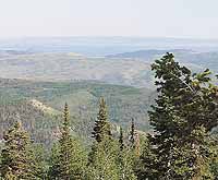
| The view from the top of Reservation Ridge, which is northwest of Price in Duchesne County, is spectactular. This photo shows the back of the book cliffs looking south and has Cedar Mountain and the San Rafael Swell in the distance. |
While most people dwell on day trips to rock art sites and red rock canyons when they travel around the Castle Country area, sometimes they forget about the great mountain scenery that is nearby. And on a hot summer day some of these areas can give some cool relief.
Reservation Ridge, while located in Duchesne County, is close enough and has a wide area of view over both Carbon and in the distance Emery County. But this is not a Wasatch Plateau Energy Loop drive; it is a pure dirt road with some rough spots over which regular cars shouldn’t proceed.
The road across Reservation Ridge can be accessed one of two ways from Carbon County. One way is to travel up Willow Creek Canyon on Highway 191, through the Emma Park/Whitmore Park area, across the county line and up toward the Indian Canyon summit. The turnoff is a short distance before the summit to the left. It is marked by an old real estate sign on a shed. It is about 13 miles from the turnoff in Price Canyon where Highway 191 leaves Highway 6.
| Elk stand in the road looking toward the camera near the turnoff to Horse Ridge Road. To the right is Larkspur which is presently very thick in the meadows. |
Another way to access Reservation Ridge is to turn left from Highway 6 on the Reservation Ridge Road (dirt) that takes off to the right about a half mile south of the vacant service station at Soldier Summit. There is a fork in the road about three-quarters of a mile from the highway, so stay to the right.
Once on the road, when traveling from the Indian Canyon side, follow the main dirt road. Much of the land for the first few miles is private property and is marked as so. This time of year (late June) people are astounded by the wild flowers that exist along the road. This year in particular the Delphiniums make the fields along the road glow blue and purple.
The area is part of the Ashley National Forest so eventually road travelers end up in federal land. One of the first things that appear once out of the private land is the Avintaquin campground which has been closed so far this spring. A spokes person for the Ashley National Forest said on Wednesday that there is no set date for when the campground will open this year. There have been so many fallen trees in the area of the campground, probably due to the heavy snow this past winter, that the forest service has not had time to clean it all up yet or repair damage from them.
Once past the campground, those who take the road will pass through a lot of pine and aspen. The road climbs and climbs and climbs. Sometimes the grade is gentle and other times it is fairly steep. This is a logging area so there are dozens of access roads that take off from the main route as well as a number of forest service roads that are labeled to take the traveler to places like First Canyon and Horse Ridge.
| Even the rocky ledges have flowers, like this Oregon Grape for example. |
The charm of this drive is the views, the tree enclosed roads and the flowers and more flowers.
For views, as one approaches the half way point between the White River and Indian Canyon, they are more than breath taking. To the north one can see the hills and mountains south of Duchesne and the snow capped Uinta Mountains in the far distance. To the south, the overlook displays Highway 6 and it’s meanderings a couple of thousand feet below. Past that one can see the top of the Wasatch Plateau and beyond that Cedar Mountain and other formations in the San Rafael Swell..
The road travels to the point where the vistas are huge and the flowers seem to go on forever. On the top the meadows are filled with wild Forget-me-nots, Phlox and various other flowers. The flora varies because of the altitude (8000-9500 feet).
Taking some of the side roads give a view that is not seen from the main road. A trip toward Horse Ridge reveals much rougher roads, but also trees and flowers in much greater variety and numbers. Throughout the area old corals can be seen where cattlemen once kept there stock.
Wildlife also abounds in the area. A tour of the road can reveal such animals as deer with their young, elk and porcupines, along with other inhabitants of the ridge.
| The meadows throughout the drive over Reservation Ridge are filled with flowers of all kinds turning the ground purple, blue and pink. |
On a cool day in Carbon County it is almost cold near the top of Reservation Ridge. On a warm day in the valley, the top is very pleasant.
The whole circular trip, depending on stops made to catch the views and the condition of the road, can take up to six hours, although it probably could be done in under three or four.
This past winter was a heavy one along the ridge and there is still snow banks along the top. The snow also created a lot of tree falls, some of them across the road. Some of the fallen trees even create arches across the road in places. With the winds from microburst storms that have been in the area lately, it might be a good idea for travelers to take a good saw and tow chain along with the picnic basket in case one of those leaning pines or aspens happens to cross the path of travel.
It’s a place not many people go, and it can also give Carbon County residents a whole new view of the country from a different perspective.