| As part of a larger water drainage system, various creeks cut across Clarks Valley. The crossings are easy to navigate in late June, but spring runoff raises the level of water to a less passable level. The crossings make passage difficult for larger highway vehicles, but more appealing for the OHV crowd. All trail users will discover that they get the area to themselves as few highway vehicles venture into the area. |
Carbon planning officials have proposed a multi-use route through the county to connect existing trails and establish a route through the county for off-highway vehicles, equestrian traffic and other recreational use.
As they have done so, planning staff has looked at the connection to Sunnyside and East Carbon City as an essential staging point.
With such a great distance between spurs to Wellington and Price, the stop in the eastern part of the county will give trail users a last chance stop in the town to refuel OHVs and stock up on personal food and supplies.
The stop also gives trail users a point where they can park vehicles.
The route into the cities approaches from the northwest, in Clarks Valley.
Starting near Pace Creek, the route goes south for almost two miles and heads east toward C Canyon Road.
The route finds Sawtooth Road some 2.5 miles later and then follows Bear Creek Road.
Along Bear Creek Road, the route crosses C Canyon Road, one of three places in the Castle Valley where trail users will have to cross a route used by coal trucks.
The other two similar crossings are at Airport Road near Price and Dugout Canyon Road.
After crossing C Canyon Road, the route continues to the southeast on Bear Canyon Road for 4.25 miles before entering Sunnyside.
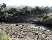
As the route makes its way from Clarks Valley Road to Sunnyside, trail users will encounter a number of washes.
Some of the washes have continual runoff, while others are dry stream beds.
While much of the proposed route through Carbon County is accessible by cars, the areas are some that are not traveled heavily by motorized vehicles, as parts of the trail are extremely rocky.
In the spring, when runoff fills the washes and gullies, only vehicles with four-wheel drive can access the area.
For those who wish to get away from the traffic of the more populated areas, the route through Clarks Valley will be one that trail users will find to be less traveled by highway vehicles.
The proposed route through Sunnyside and East Carbon enters the cities from the northwest on Bear Canyon Road. After a jog around the golf course, the route joins Grassy Trail Drive near Grassy Trail Creek.
The route goes south along Grassy Trail Drive to East Whitmore Drive. At 200 East, the route heads south to Utah Highway 123. All OHV users will be required to cross the highway at right angles.
The route then follows Highway 123 to the east. Sunnyside and East Carbon have specified that a trail along Highway 123 and then along Grassy Trail Creek is the approved route for OHV traffic through the cities.
This route gives trail users easy access to the cities’ only gas station at the corner of East Whitmore Drive and 200 East in East Carbon, as well as Miner’s Trading Post in Sunnyside.
Both Sunnyside and East Carbon have established ordinances regarding OHV traffic in their cities. So trail users will have to abide by these ordinances as they travel through the towns in eastern Utah.
Dave Levanger, county director of planning said that the county will work with cities to follow ordinances and route that are already established. So as Sunnyside and East Carbon continue to develop more encompassing plans as far as OHV and other traffic through their cities, the county’s plan and route will be adjusted accordingly.
After the route proposed by the county leaves Sunnyside, it heads up Whitmore Canyon Road to Bruin Point Road. As the route goes over the top of Bruin Point, it crosses the highest point of the trail at an elevation of 10,131 feet.
Editor’s note: The article is the second in a series of four stories concerning the suggested route and issues relating to the proposed multi-use route across Carbon County.