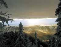
| This is a beautiful winter time view looking out over some of the property involved in the recent land swap between Hunt Oil, the DWR and the Tavaputs Ranch. The new loop road that is created by the trade will likely benefit the entire area. |
A historic land swap in Carbon County concluded months of meetings and hearings prior to New Year’s as 2,600 acres of mountain plateaus were switched between two private ranching operations and the Utah Division of Wildlife Resources.
The trade lifts a conservation easement off Buckskin Ridge and places it on a parcel of land previously owned by Hunt Oil. Buckhorn Ridge was part of the Wilcox Ranch sale to the DWR three years ago.
The new easement was placed on Cold Springs, which lies on the northwest corner of the Tavaputs Plateau south of Nine Mile Canyon.
The move opens up tens of thousands of acres of previously inaccessible public land. Because of the switch, a public road now connects Sunnyside and Bruin Point to Nine Mile Canyon.
“Literally tens of thousands of acres of public land that were essentially inaccessible to the public are now accessible for tourism, recreation and hunting. An amazing loop going through Nine Mile Canyon, up Cottonwood Canyon, then over Flat Iron Mesa and through Cold Springs to Bruin Point and down to Sunnyside will be formed,” explained Carbon County Commissioner Steven Burge.
The land swap did not happen overnight.
Blair Eastman, local Hunt Oil manager, indicated that the seed was planted about six years ago when Carbon County officials approached the company about opening up the road through the ranch to connect Nine Mile Canyon to Bruin Point.
The action was not a possibility for Hunt Oil, a private company that had purchased the Preston Nutter Ranch in 1993.
The property, located in Carbon and Duchesne counties, is the site of an historic cattle ranch founded by Preston Nutter in the mid to late 1800s.
A lawsuit and hearing followed the transaction. It was subsequently determined that Hunt Oil could keep the gate locked through the company’s property.
Carbon Commissioner Bill Krompel later met with Hunt Oil officials and requested that they reconsider the company’s decision.
Hunt Oil senior vice president Thomas Meurer initially denied the request.
But according to Eastman, the Hunt Oil vice president “felt a little guilty and came back to his management team with a proposal to “figure out a way to make this happen.”
“That is when we proposed this alternate route,” explained Eastman.
Hunt Oil agreed to donate a “fee title” easement on a road that the company built, which amounted to approximately 25 acres.
Eastman said Krompel thought a road was necessary not only for accessibility by the public for recreation, but for county search and rescue as well as fire suppression.
At the same time as the road situation was being resolved, southwest regional DWR director Derris Jones explained that Don Peay facilitated a meeting with area sportsmen.
The sportsmen group wanted to have access to more public areas that were behind locked gates.
The Wilcox property in Range Creek was for sale and the public agencies started the procedure to purchase the property as a wildlife sanctuary.
Legacy program official Ann Price with the Utah Division of Forest, Fire and State Lands initially coordinated the conservation easement that was a key component of the $2.5 million purchase of the Wilcox property.
The quality growth commission played a major partner in the accusation, noted Price. Initially, the panel put up $500,000.
However, the quality growth commission’s contribution toward the purchase mandated that the land involved in the transaction become a wildlife conservation area accessible to the public.
The 2,600 acre Buckhorn Ridge parcel was removed from the Range Creek site and connected by a steep dirt road up Creep Canyon, which ran across private property owned by Butch and Jeanie Jensen
The couple own Tavaputs Ranch.
After the purchase, the DWR and state officials discovered that the Utah agencies did not have access to the property.
“It was an oversight at the beginning,” explained Price, who said it was first determined through a title search.
So for the last three years, the state agencies struggled with a piece of property that mandated public access, but located in the middle of a private ranch.
The state agencies had access to the land that the Utah departments administered, but the general public was never allowed through the locked gates.
When news of the Fremont Indians artifacts and archaeological finds in Range Creek hit the international airwaves last summer, the dilemma was the lack of public access intensified.
It was at this point, in mid-July that meetings began to discuss the trade of the three parcels of land. Agencies involved over the course of the summer and fall included the Department of Natural Resources, Department of Wildlife Recourses, Department of Forest, Fire and State Land, Carbon County, and Attorney General’s Office.
Monumental act of lifting the easement off Buckskin and replace it on Cold Creek.
As far as Price knows the changing of an easement from one property to another has never been done in Utah before, “at least this was a first her me.” The easement, now on Cold Creek, determines that it will never be used for development.
Price explains that “It was a tidy switch” The new piece that the has a road, now owned by Carbon county, through it has a greater resource value. It was appraised for $60,000 more than Buckskin Ridge property.) Cold Creek is a high plateau, good for grazing, and offers wide variety of wildlife habitat.
It’s a “Better Deal for the Public,” she explains. The win-win situation offers a greater area to hunt with no turn-rounds and easier accessibility. “The winner here is really the citizens of Carbon County.”
Quality Growth Commission, the group that funded a half million dollars of the original Wilcox sale needed to sign off on the easement switch and prior to their decision they toured Cold Springs. According to Price they “were blown away with the property,” It was unbelievable, she explained. The first thing they encountered was a herd of wild mustangs. “They saw it all, from wildflowers to wildlife.” They gave their blessings to the land swap following this tour.
In November Mike Milovich, chairman of the Carbon County commission, wrote a letter to John Harja of the Governor’s Office of planning and budget and reiterated the commissions strong support for the proposed land exchange. “Since the letter dated July 27 was written, we have continued to participate in the meetings between the interested parties and have performed surveys on the road and provided other assistance,” he wrote. The hearing was advertised and following the hearing the Commission formally voted to support the project and approve their participation in it. “It is our intent to more fully develop the road through the land in order to increase public access to a beautiful region.”
Milovich continued, “One of the greatest advantages to this transfer is that individuals driving up Nine Mile Canyon will be able to take a loop up Cottonwood Canyon, through Cold Springs, to Bruin Point and down through Sunnyside and East Carbon. The loop will give visitors an incredible view of and access to thousands of acres of public land.”
The advantage for Jensens is that it consolidated their ranch. “For us it was a win-win situation,” explains Butch. The Tavaputs Ranch had a gap in the middle. It put the former Wilcox summer grazing land back with the ranch where it was prior to the sale of Range Creek. “It also gave the public a parcel that is accessible to them.”
It also firmed up the Hunt Oil property giving them 2600 acres that was on their extreme south edge, formerly part of the Tavaputs Ranch. This area included the Gooseneck Ridge and is very similar to Buckskin Ridge. Hunt Oil company offers a retreat area for friends, family and business guests. It does contain a hunting lodge with annual elk and deer permits, but it is a working ranch. “We have no plans for any oil or gas development,” explains Eastman.
For Derris Jones the trade will make it easier to complete his DWR management plan. “The problem before was completing a management plan to an area (Buckskin Ridge) that had mandated public access but was very limited to any access at all. Jones explained that a handful of people had squirted the private land and made it to Buckskin, but with because there were no accessible roads it made it nearly impossible for hunters to get their deer or elk off the plateau.
In the Milovich letter he addressed the controversy saying that the commissioners recognize that there were a few opponents to the project and, “we have respectfully considered their viewpoint. Like most things, there are pros and cons. In this case, it is our belief that the advantages to this exchange greatly outweigh the disadvantages and we believe that not only the citizens of Carbon county but all citizens in general will greatly benefit form the completion of the exchange.”
“Plus for us, the number one issue according to law, was that the property had to have public access and it never would,” he explained.
Jones said that the Cold Springs parcel is very similar, yet different the Buckskin Ridge. Both are similar elevation but Jones feels the Cold Springs area offers better deer hunting, but not as good elk hunting. There is more of a mixture of conifer trees and less aspen trees. Price explained that the Cold Springs property does have a wider variety of wildlife and also has large herds of wild horses.
The Cold springs land will allow limited entry for elk hunting through drawings as well as a Southeast Regional Deer permit.. Jones says that the public can always make recommendations to change these provisions.
The DWR will be working on two management plans, one to oversee the Range Creek Property and the other to manage Cold Springs.