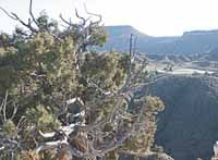
| A lone gas well operates near Wattis in the southern portion of Carbon County. The Price BLM field office’s draft resource management plan will affect many aspects of public land use in the county, including mineral development, livestock grazing and recreation venues. |
In October, the United States Bureau of Land Management extended the comment period on the Price field office’s draft resource management plan until Nov. 29.
Originally, the comment period was to end more than a month earlier. But due to requests the BLM received from the public and government entities, the federal agency extended the timeline.
Activists who oppose the way the RMP is developed have been contacting residents of Carbon and Emery counties about the document and asking local citizens to send in comments before the the Nov. 29 deadline.
“I just think the public needs to be aware of how the RMP can affect them and their activities on public land,” noted Scott Wheeler, an all-terrain vehicle activist from Price.
On Monday, four people contacted the Sun Advocate about the impending deadline and wanted to be sure that people were aware the comment period was rapidly coming to a close.
The BLM originally released the draft RMP to the public on July 16 for review and comment.
“The public’s input is critical since this RMP will guide management of more than 2.5 million acres of public lands,” said Price BLM field office manager Patrick Gubbins when the public comment extension was authorized. “We understand that this is a very complex document, the culmination of two years of work by BLM, our cooperating agencies and the public. We want to make sure the public and our partners have the time that is needed to understand the document and provide substantive comments.”
Opponents of the plan point out that it has many descrepancies in it and in some cases contradicts itself. They say it is also lacking in some areas and in some cases could make it very difficult for some visitors to public land controlled by the agency. They say that the way the plan is written could impact the following areas as well as others.
•Group activities. The opponents say that new rules could control groups as small as 10 people. Some aspects of the plan could make it so families or friends would have to apply for permit to use public land, months in advance.
•It will affect trails and roads that are presently used by the public and recreationalists. According to opponents the proposal will greatly reduce the number of roads, trails and routes used by full sized four wheel driver vehicles, motorcycles and ATV’s.
•That the plan, as it exists, had little input from local governmental entities and that the economic impacts of the plan on the local area were not studied properly.
•That the plan expands wilderness areas by using a variety of terms that create a defacto wilderness without actually calling it that.
Carbon County officials also have concerns with the RMP as well.
“We would like to let people know that we believe the RMP could have serious implications for the county and its citizens,” explained Carbon planning and zoning director Dave Levanger at a meeting of the local recreation and transportation special service district in September. “We do not agree with the plan, have consistently opposed many parts of it and see little consistency with the plan we have developed for managing the county’s lands.”
Others in the community have also seen problems with the plan, particularly when it comes to the issue of consistency.
“The consistency of what they have presented in the plan questionable,” indicated Alan Peterson, a local multiple land use advocate. “I went to the meeting in Emery County (in August) and asked where the map was located that showed roads recognized by Carbon in the plan and they didn’t have it. Then at the meeting here in Price, they used the map I was asking about in the presentation, but it wasn’t included in the actual plan. I was then told that they would use that map in the plan. Then at the Salt Lake meeting, the Southern Utah Wilderness Association representatives went ballistic because the BLM showed that map on the screen again but still didn’t have it included in the document. What are we supposed to comment on? What’s contained in the document or what is in the meeting presentation?”
Wheeler questioned the inconsistencies in the BLM’s draft plan regarding off-highway vehicle use.
“They didn’t even address it properly,” said the local off-highway vehicle advocate. “Actually, they included 150 miles of blacktop roads in the off-road inventory.”
The county has produced some documents pointing out the problems Carbon officials see with the plan. For the most part, Carbon’s objections center around the following areas.
•The county wants the RMP to match what local officials have approved as a master plan. The present form of the RMP doesn’t do this. The county said it is committed to multiple use and sustained yield on public lands. A lawsuit called Uintah vs. Norton was filed in 2001, which had to do with the BLM trying to introduce horses into an area where the county master plan did not allow it. Uintah County won the suit and kept the horses out. That set a precedent for a county’s master plan to hold measure over federal mandates.
•The county has voiced its opposition to layering of land uses and restrictions. These layering methods include various kinds of laws and regulations including visual resource management, areas of critical environmental concern, wild and scenic rivers, special recreation management areas as well as other acts that tie up land for particular reasons. The problem the county sees with these kinds of regulations is that they can be used to the extreme.
For instance, visual resource management could mean that if a gas well head could be seen 50 miles away in a wilderness area, the area that gas well is in could be regulated. In another instance, according to county officials, the Wild and Scenic Rivers Act could impact every drainage attached to a designated river. This means, for instance, that the entire drainage system in the Desolation Canyon area could be made de facto wilderness by the Green River’s designation as a wild and scenic river.
•The county said it supports protection and management of watersheds, but dislikes the idea of corridor management, such as is found in the Wild and Scenic River designation.
The problem with this designation is that often there are bordered lands that are affected by the act and in some cases these restrictions can go well beyond the boundaries of the river itself, affecting side drainages far away from the intended protected areas.
•The county also opposes any reduction in grazing rights. The county has a policy of no net loss of private lands, animal unit months (AUMs), or water rights to public agencies.
•The county sees the present form of the RMP as being driven by recreation, rather than by other uses of the land. This could result in job loss and other impacts to the county. The county said it feels that minerals, agriculture, timber and other land uses should be on a par with recreation when determinations are made about how land should be used.
•The county also has concerns about the forested properties the BLM controls, because some policies could allow harmful insects and wild fires to spread onto privately held adjacent lands.
•The use of a recreation opportunity spectrum also troubles the county. The use of parameters to close existing roads and ignore the existence of some roads is opposed by the county. The counties accepted transportation plan, which recognizes roads in the county, was not included in the document.
•The county adopted a wilderness proposal in April of this year and it complies with the recreational opportunity spectrum and the county expects the BLM to adhere.
•The county is concerned about the clarity of the maps used in the document.
The county also notes that the length and inclusiveness of the plan is too complex, making environmental assessments obsolete and creating a situation where following the parameters of the National Environmental Protection Act (NEPA) would be nearly impossible. This, in effect, would keep land from being used for almost anything at all.
While there are a lot of avenues to explore, it seems many in the public, are most concerned about road closures and changes to routes. In the final plan, the BLM says it will designate areas as open to motorized travel, closed to motorized travel, or limited to designated routes.
For the limited category, BLM will also designate which specific routes will be open to motorized use. The route designations made in the 2003 San Rafael plan will be incorporated into the final RMP.
“There are more than 3,500 miles of existing routes in the management area,” explained Gubbins. “We do not plan on designating all of these routes as open; rather, our goal is to create a designated route network that protects other resources and provides both motorized and non-motorized recreational opportunities.”
The BLM also says, contrary to opponents assertions, that the plan wasn’t put together in a vacuum. They say that the draft resource management plan/environmental impact statement was prepared with the assistance of four cooperating agencies as well as input from the public during the scoping phase of the effort, indicated the Price BLM office.
The document may be viewed electronically or local residents may call the Price field office at 636-3600. Comments may be submitted via the website or sent to Price Field Office RMP Comments, Attention: Floyd Johnson, 125 S. 600 West, Price, UT 84501.