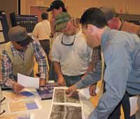
| Sacco Brothers Ranching representatives meet with a Utah Department of Transportation U.S. Highway 6 team official about proposed changes to the road in areas that affect the agricultural operation. The town meeting consisted of a series of stations where Carbon County citizens could review the different aspects of the draft environmental impact statement and submit public comments on the proposals. |
Last Thursday, representatives from the Utah Department of Transportation set up 10 information stations at the College of Eastern Utah Student Center.
The stations told the story of U.S. Highway 6 and how changes in the road’s corridor will affect people, landscapes, wildlife and the ecology of the local area.
The subsequent town meeting was conducted to accept comments from local residents on the draft environmental impact statement that addresses the proposed changes for U.S. 6.
A DEIS must be completed when federal funds are used to build transportation venues. The National Environmental Policy Act specifies the statement’s completion and requires that community involvement be one of its main objectives of the plan.
The DEIS must also specify the whats and whys of the project, any and all alternatives that may be available for the corridor, what the potential impacts of the project are on the human and natural environment and what mitigation can be done to keep negative circumstances from affecting the corridor.
The U.S. 6 DEIS covers an area of 127 linear miles from Spanish Fork through Price Canyon past the East CarbonJunction on to Interstate 70 near Green River. The intention of UDOT is to design and construct the changes to the highway to improve the capacity and the safety of the corridor.
In the past, citizens have lobbied toward building a four-lane highway the total length of the section under study. After some construction in the last few years, the amount of three- to four-lane areas has grown on U.S. 6.
When the DEIS process was initiated, out of a total 61 miles there was 47 miles of two lane road between Spanish Fork and Helper. From Helper to 1-70, seven out of 66 miles were three or four-lanes.
Key areas addressed by the DEIS include the reduction of cross-over accidents between vehicles traveling in opposite directions; the reduction in traffic congestion, which UDOT said will steadily increase based on growth statistics; and efforts to find a way to improve the Peerless port of entry north of Helper.
The road does not conform to modern design standards. The study looks at a variety of changes to make U.S. 6 more efficient and safe.
One alternative UDOT had to examine was to not do anything in terms of construction, but to change the type of traffic or how traffic is regulated on the road.
One option is to solve the problem by installing better signage, improving median and shoulder barriers and improving the striping on the road. Some of these alternatives have already been done on some sections of the road and have proved moderately successful.
Another way that the road could be safer for passenger vehicles might be to restrict truck traffic on the road or reduce the speed limit. However the road is a major route for large trucks and some businesses in the area depend on that flow of big rigs for their economic well being. Speed limit changes were also reviewed.
As for actually changing the road through construction, the department looked a several options. The first is to include more passing lanes with more median barriers where needed. They also listed four lane alternatives as well. That would mean large construction projects in places like Red Narrows in Spanish Fork Canyon as well as in Price Canyon.
After looking at the alternatives, UDOT engineers have determined that the only options that totally meet the objectives are either more passing lanes or a four lane highway for the entire 127 miles.
In addition to widening the road, the DEIS also looks at other work that must be done. At least three interchanges would need to be changed or rebuilt and a number of realignments of intersections that are presently on the highway would have to be completed. Of most interest to local citizens is improvements on the Scofield Junction intersection, the realignment of U.S. 191 near the Price Canyon Power Plant, the extension of Highway 157 (Kenilworth Road) to U.S. 6. and creation of an interchange, followed by the elimination of the entrance and exiting of traffic from the Spring Glen intersection near the Carbon Country Club and Consumers Road. There would also be the realignment of Sunnyside Junction. With the four lane alternative, UDOT is also looking at constructing a tunnel on the north side of the highway to improve the narrow and sharp curve at milepost 192 in the Red Narrows.
The Peerless Port of Entry is of major concern to almost everyone that deals with it. While it could be left like it is, UDOT engineers have determined that the two best alternatives are to either vacate the present stations and build virtual scales for the highway (trucks would use transponders to provide information about them) or to build an entire new port of entry at the proposed Spring Glen/Kenilworth Road interchange.
The passing lane/four lane alternatives would take 10 to 20 years to build because funding for the entire project would be cost prohibitive. Projected costs for each alternative based on todays dollars would put the price of passing lanes in key areas and other improvements at $595,758,000. For the four lane option, the cost jumps to $678,400,000.
Individuals have until Oct. 29 to submit comments on the DEIS. The project website is www.udot.utah.gov/us6. Questions about the project can be addressed to Nicole at Donegan@ hdrinc.com or by calling (801) 281-8892.
Once public comments are in, the UDOT project team will review them and incorporate them into the final draft environmental impact statement that should come out sometime this winter.

