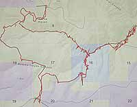
| The red line pinpoints the route Tim Pilling followed through SITLA and BLM property to gain access to the wilderness area south of the Hunt Oil property. The blue designates SITLA land. The green designates BLM land and the purple, Hunt Oil property. SITLA section 16 is for sale and the proposed Hunt Oil-BLM land swap will include acreage from sections 19 and 20, creating a continuous bridge of private property. |
The ad ran in the classifieds under “lots and acreage” in a late August issue of the Sun Advocate
The Utah School and Institutional Trust Lands Administration is selling approximately 40 acres of SITLA property near Castle Dale and land on Summerhouse Ridge in eastern Carbon County, stated the ad.
The sale of SITLA land frequently generates little interest within the general public. The money goes directly to one of 12 different beneficiaries or into a fund from which SITLA earn money. The beneficiaries are state government agencies, ranging from public school districts to reservoir operations.
SITLA offers land regularly. Last May, SITLA sold section 32 for a minimum bid of $278,400 to Hunt Oil.
SITLA makes money for beneficiaries from more than the sale of land. In fiscal year 2001, the agency posted revenues of $54.8 million from activities on the lands administered by SITLA. Almost 80 percent of the income came from mineral extraction, including coal, gas and oil.
SITLA land with no apparent potential for generating funds is often sold one section at a time. That is the story of the Summerhouse Ridge property, which will start a bidding process Oct. 1. The parcel however, is not just 40 acres, but a section of land in rugged country: 640 acres of steep walls, canyons and mesas on the edge of the Desolation Canyon wilderness study area. That plot of land is called Section 16, T14S, R16E.
In Utah, there are more than 2,300 surveyed townships. Each township includes 36 square miles, each considered a section. While Utah was still a territory, the federal government granted western states two sections in each township – generally sections 16 and 36 – for the support of common schools. But when it came to Utah, New Mexico and Arizona, the United States government granted four sections of land in each township – sections 2,16, 32, 36.
The administration of the land has been run by various boards and commissions since the state was formed in 1896. At that time there were 7,475,297 acres granted to Utah.
After years of various administrations to control the lands, the legislature created SITLA to administer the lands in 1994.
With sales and land swaps over the years, what remains today is a total of a little under 3.5 million acres. SITLA also controls the mineral rights to another one million acres that they do not own the surface rights to.
SITLA land is now the only “new” supply of private land available in the state. The Federal Government seldom sells land, and with the ability for people to homestead in the 1970s, there is little opportunity to obtain present federal property.
SITLA has also consolidated a great deal of its land over the years. Through land swaps and trades, there are places where SITLA has huge amounts of property, in fact near whole townships. The Drunkards Wash area of western Carbon County is a good example of a place where the agency traded sections of its land in other places to the federal government to obtain that ground in one huge block. It has been a very worthwhile trade for SITLA and its beneficiaries, because that area is one of the biggest coal bed methane producing fields in the country, thus royalties from the production fills the state agency’s coffers.
But Section 16, that covers Summerhouse Ridge, parts of Flat Canyon and Summerhouse Canyon is different. It is an undeveloped piece of property that is hard to get to and in most ways relatively useless in terms of income. Thus it is for sale. And looking at a map it makes sense that Hunt Oil would want to buy it because it would attach nicely to land they already have in the area.
However, for some this section of land has been the entrance to a natural playground for years. Hikers, campers and hunters have used the area for recreation for a long time. There are those that oppose the sale.
But the sale of this section of land alone is not what some of these opponents are worried about. The United States Bureau of Land Management is now also under negotiations with Hunt Oil to do a land swap nearby. The two land deals, when put together, opponents say, could cause a potential blockage of public access to thousands of acres of federal public land south of the two pieces in question.
“I have been going there for years, and I can’t see another way to get into the property south of the Hunt Oil holdings by land,” said Tim Pilling, a long time user of the area. “If those two actions happen, access from the north will be closed off. Access to the west and south is also blocked by private land. The only way in would be from the Green River in Desolation Canyon or by air.”
Pilling, who has been an activist to protect access to the land, has been asking a lot of people questions about the situation. He has also spoken to Carbon County officials many times about protecting the access. Recently Pilling hiked the entire route that would be closed up and took geographic positioning points to show that route. He then relayed them to the county’s planning and zoning department for study.
“He’s right, ” says Dave Levanger, director of planning and zoning for the county, as he points to a map created with Pilling’s coordinates noted on it. “According to how we have charted the GPS points he did, the swap would close up that particular portal to the BLM land to the south, but I am not entirely convinced that is the only way into those public lands.”
Levanger used the map to illustrate what he thinks might just be another land route in, that flows around the eastern end of the present Hunt Oil property. While that route looks rough on the map, it may be passable on horseback or on foot.
“Trails aren’t viable here because it is a wilderness area, so no new trails can’t be built, but there is probably a way through there,” states Levanger.
Pilling said that the area Levanger refers to is too rough to go through, with steep cliffs and canyons in the way.
While Pilling and others are concerned about the proposed land swap between the BLM and Hunt Oil, the trade seems a good idea to the county.
“What is going to happen through this is that the pieces of the Nutter Ranch to the North, now owned by Hunt Oil will become public areas,” states Levanger. “More importantly the negotiations for the land will open up a section of road that has been blocked to public traffic for some time in Cold Springs Draw.”
Some of the controversy over the purchases has also been about other roads that exist in the area. The county was able to negotiate for one section of road through a piece of Hunt Oil land to the north that was previously owned by SITLA, but another road that runs through that same section of land in the southwest section of the property remains closed to the public. Some have argued that the county should have a prescriptive right of way through that section because it once was public land.
“True it was public in the sense SITLA owned it,” commented Levanger. “But when it comes to a lot of things state and particularly SITLA land is treated more like private land.”
While roads on Federal lands are public, on state lands the Utah State Legislature has left a loophole for state and private land to get out of having to ensure passage on a long existing road by making it so that if an agency or owner closes a road once within 10 years (for a day) it cannot be construed as a public right of way or road (Utah State Code 72-5-104).
Another factor some are concerned about are archaeological sites on SITLA land that is sold to private owners. But SITLA said it has a specific protocol for bringing land parcels to the sales block, which include such things as evaluating accessibility, assessing on-going revenue potential and performing archaeological surveys and providing mitigation for the site if needed. The agency has its own set of archaeologists who work with private and other agencies to review and protect cultural resources on their lands.
“I have seen some archaeological sites on lands they sold before they were auctioned and around the one they presently have for sale. I have requested information on some of those sites to see if their archaeologists noted their existence,” stated Pilling. “I really think that some of the sites have been missed, that they got passed by during the inventories.”
But the existence of artifacts and structures on trust land does not preclude it from being sold, because it is administered for the good of the trust. In fact when section 32 in the same area was sold last Spring, Hunt Oil reportedly spent $27,000 bringing in archaeological consultants to help them be sure any sites were identified and protected on their new acquisition.
“I just worry that this will lock up land that people should know about,” explains Pilling. “The Desolation Canyon wilderness study area is one of the largest proposed wilderness areas in the state with approximately 290,000 acres. If you have not seen or been in or around the canyon it is a giant, deep gorge similar to the Grand Canyon with several large side canyons going up to the Tavaputs Plateau on the west. There are immense areas of land west of the river with unparalleled wilderness qualities that have not been seen by many or utilized due to the shear size and raggedness of the terrain. I have seen this part of the canyon and would like to ensure that the access is protected for people to explore and enjoy.”
The auction for the sale of Section 16 will take place on Oct. 1 in Salt Lake.
The land swap between the BLM and Hunt Oil is still pending.