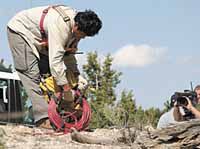
| A Polaris Explorer Ltd. worker spreads out cable in readiness for a “hole shot” as television cameras roll during a demonstration near Prickly Pear Canyon on Tuesday. A group of 35 officials and media made the trip to see the techniques that are being used to map the deep geology of the area. |
Officials from government agencies, businesses, various citizen groups and the media descended on Cottonwood Glen in Nine Mile Canyon on Tuesday to find out what the seismic testing in the area was all about and how it would affect the cultural and natural resources in the area.
While the group that showed up was not near as big as the media frenzy at Range Creek earlier this summer, it was still a formidable number for the Bureau of Land Management and the Bill Barrett Corporation, the sponsoring organizations of the tour and demonstrations, to transport around the area.
“We started the process of studying this operation almost two and a half years ago,” said the BLM’s Mark Mackiewicz in a meeting at the picnic pavilion. “It was 22 months in the making to produce the environmental assessment. We employed many different disciplines to get the EA done including archaeologists, biologists and even a professional ethnographer to work with the various Native American tribes who have interests in the area.”
Mackiewicz pointed out that the study encompassed 90 square miles and 58,000 acres of land around Nine Mile Canyon.
“We spent a lot of time on mitigating any effects on cultural and wildlife resources,” he said.
There are two types of seismic work being done in the area. One is a process of using a small amount of dynamite inserted in a drill hole 50 feet below the ground. When it is activated it sets off sound waves that are measured by surface microphones (geophones) that are strategically placed in the geographical location.
The other system uses a series of vibrating machines that work in tandem as they drive down a road putting out a series of waves into the ground via hydraulic pads under them. These are also measured by geophones and the information about the structures that exist under the ground is recorded. This process is know officially as vibroseis.
The concern for many has been the effect the vibrations from both types of operations may have on rock art and other artifact sites in the area.
“Part of our mitigation efforts has been to have professionals on site at all times to assure the protection of the resources,” said Mackiewicz. “While this has been going on we have had Montgomery Consultants (an archaeological firm) from Moab on the site at all times. The company has also secured the services of Matheson Mining to monitor the shock waves and be sure they do not exceed the thresholds established.”
The entire project is know as the Stone Cabin seismic survey. The study is located on the West Tavaputs Plateau where a gas field has actually existed since the 1950s. Widespread drilling activity has occurred in the project area in the past, with 48 abandoned or shut-in wells left as evidence. There are currently 19 wells capable of producing gas in the area. The Bill Barrett Corporation is the firm that is presently having the survey done, with the help of a Canadian seismic study company named Polaris Explorer, Ltd.
The project area does not include Nine Mile Canyon proper. However, 10 percent of the project is taking place in the tributary canyons including Cottonwood Canyon, Harmon Canyon, and Dry Canyon. In these canyons, seismic activity is being limited to use of existing roads using vibroseis. To protect cultural resources, a distance of 300 feet is being maintained from all known rock art and standing structures.
The Stone Cabin project parameters do not authorize any additional development in the area. Much of the present development in Nine Mile Canyon is on state and private land where BLM has no jurisdiction. According to officials, by law and under its multiple-use mandate, the BLM must recognize valid and existing oil and gas lease rights in the area.
“I think it is important to understand that we have people on the ground who are reporting directly to us daily and weekly,” said Mackiewicz. “This is one of the few projects that has had such close daily monitoring. I believe that when this is all over there will be few signs the seismic company was ever here.”
Of course, the process of placing charges of dynamite 50 feet below the ground is not an easy one and Mike Fitzmorris of BBC explained how that is done to avoid making a mess on the surface.
“Because of the rugged terrain, a lot of the hole shots we are having to do are in areas unaccessible by road.” he told the group. “Much of the work done in these areas has been done with helicopters which flew in the compact drilling buggies and then lifted them out again once they had finished.”
In other areas drilling buggies with large tires that spread out the weight of the machine so as not to damage the surface maneuvered across the landscape, drilling the holes for the charges.
“One of the things we have also been doing is flying in the crews from the Price Airport in the morning so the traffic on the road in Nine Miles is greatly reduced,” said Fitzmorris. “Of course once they are here we have to transport them to work areas in vehicles.”
Fitzmorris explained that the reason for the testing is to look at the geology of the area down to a depth of 13,000 feet and to find likely areas where wells could produce hydrocarbons.
“If we can define these areas geophysically, then the chances of success for a well are much higher,” he said. “That means fewer dry wells that have to be reclaimed and that certainly reduces the surface impacts.”
As the tour began, those present noticed a series of cables running across and alongside roads above the canyon rim.
“Those are the cables that send the information back to the recorders when the seismic tests are being conducted,” said Myke Mitchell, the operations mapping coordinator for Polaris. “The various colors depends on whether it goes to a group or is a cable that travels to a recorder in the doghouse.”
The doghouse Mitchell referred to is the gathering point for data and where control over the seismic operations takes place.
The group stopped at one spot just above Prickly Pear Canyon to experience one of the hole shots the geologists are using. People in the group could hear various shots going off in the distance and then waited for a shot at the hole they were observing.
“The shot seldom sends any dirt or debris into the air at the drill hole because of the way it is sealed,” Fitzmorris explained. “If that happens it would be very unusual.”
The hole shot the group experienced was observed as just a thud under the ground and no noticeable surface disturbance showed up. For most, the 20 minute wait was anti climatic.
The group was then taken to Dry Canyon where vibroseis trucks were demonstrated. Company employees set up water cups, golf balls on tees and a seismographic monitor to show the different vibration levels at various distances from the trucks. The feeling caused by the trucks for many in the crowd was described like that of a large truck passing by on a highway. In the test the seismograph showed that even at 50 feet away the levels were lower than officials had previously determined were safe at 300 feet.
The project is now over half completed, with two to three weeks of work before it is finished.
“There have been many precedents set on this project,” stated Mackiewicz. “One of the most important is the fact that every employee on this project had to go through environmental training. I think that is why we have had no major problems with that issue during these operations.”