The 900 square mile San Rafael Swell is a wild desert region located primarily in Emery County. Approximately 25 miles from Price, the Swell occupies an oval-shaped area 65 miles north to south and 40 miles across.
Historically, the swell was crossed by various expeditions during the exploration of the west, but received virtually no permanent settlement.
The majority of the tracks crossing the swell resulted from prospectors in the early to mid-20th century. The tracks provided the only access until 1972, when Interstate 70 was constructed.
Various I-70 exits currently allow easy entrance to the middle section of the swell and link with the mining tracks.
Hiking and exploring attractions entice people to visit the swell. There are trails to mountains, historic sites, old mines and numerous canyons to explore.
The San Rafael River through the “Little Grand Canyon” makes for a pleasant flat water trip by raft or canoe from May to June.
Two popular scenic drives include the Wedge Overlook, Buckhorn Draw and the Temple Mountain Goblin Valley roads.
The Wedge-Buckhorn road represents the most dramatic route through the swell. At the wedge, visitors may view the impressive Little Grand Canyon carved by the San Rafael River. The Buckhorn road drops from the wedge through a narrow sandstone canyon lined with cottonwoods to a crossing on the San Rafael River.
Residents and travelers should consider touring the following areas on the San Rafael:
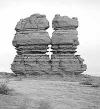
Erosion has created unique shapes in the buff-colored sandstone on the Head of Sinbad.
Deep within a canyon in the southern end of the swell lies Hidden Splendor, once one of the biggest uranium mines in Utah.
Muddy Creek can be followed through the San Rafael Reef when the water is low. Nearby is Keesle Country, a maze of canyons.
Hondoo Arch is located above Muddy River and the area offers places for hiking as well as camping.
Little Wild Horse Canyon cuts through the San Rafael Reef for two miles Near Goblin Valley State Park. The narrow canyon makes for a good short day hike.
Black Dragon Canyon has interesting pictographs. The rock formation includes a dragon, geometric shapes and human figures.
There is also impressive rock art along Buckhorn Draw.
The San Rafael Swell desert is uncompromising in summer, with little cover and temperatures routinely exceeding 100 degree. Spring and fall are better options, with more moderate temperatures. Few people visit during the cold winter months.
In addition to hikers and photographers, the red rock wonderland of the San Rafael Swell is a popular destination for off-road vehicle users.
The Hidden Splendor uranium mine was famous in Utah. Originally named the Delta, the mine closed in 1957 without reaching its estimated potential. The abandoned mine site is tucked away in a canyon at the southern end of the swell. The area is best explored on foot. Hidden Splendor is 44 miles south by graded road from I-70, ranch exit 129.
The United States Bureau of Land Management controls the majority of the swell. Dispersed camping is allowed without permits. But camping near the Wedge Overlook is restricted to designated areas.
Motorized travel is limited or prohibited in certain areas to protect sensitive resource values or maintain specific recreation opportunities. Contact the Price BLM field office for current information about travel regulations and comply with posted restrictions.
Since the San Rafael is so massive and there are so many areas that can be enjoyed and explored it would be nearly impossible to estimate a specific amount of time. Access to the swell can be from either of several major highways which include south from US-6, US-10, I-70, and SR-24.
Contct Castle Country Tourism at 435-637-3009, or the Bureau of Land Management at 435- 637-4584.
The Swell offers many day trip opportunities this fall