| The Utah Territory as it appeared in 1860. At that time it encompassed almost all of Nevada, all of Utah, as well as parts of Wyoming and Colorado. As the map depicts, some of the counties were huge. |
For most people names of places, towns, cities and counties and even countries are just something that exist. Few think about where those names came from. Even fewer wonder about how those names and geographical boundaries might have changed over the years.
Most Utahns have heard of the Utah Territory, that piece of land that was Utah before it became a state in 1896. But few know the history of how that territory came to be. And even fewer realize that many of the county lines within the state that exist today have changed a great deal in the last 130 years.
In 1850 Congress passed a bill authorizing the territory of Utah, but it was much smaller than the proponents from the area wanted. First of all, the pioneers wanted it called the State of Deseret. Secondly, as proposed, it was a huge state. It actually took in all of present Utah, parts of Idaho, Oregon, Colorado, New Mexico, much of Arizona and Nevada and a southwest corner that took in a good part of southern California, including the port of San Diego.
However the cut down version Congress approved looked much different. It took in all of Utah, all of Nevada, except the very southern tip, most of the west slope of the Front Range in Colorado and a small section of southwest Wyoming.
With territory status came the naming of counties, and many of them were very different from those that are known today. In fact there are many that presently exist that didn’t exist in the mid to late 1800’s and many that were around then that are now dissolved for one reason or another.
In 1860 the Utah Territory had 23 counties, a few large in length, some others spanned in width what is today parts of three western states. For instance, Washington, Iron and Beaver Counties all stretched from the west slope of the Front Range in Colorado to two thirds of the way to the present western boundary of Nevada.
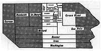
In what is present day Utah there are also a number of “unusual” Utah counties as well. Malad and Greasewood counties took up what is part of the Box Elder County of today. Tooele County was divided up between itself, Desert, Shambip as well as Cedar which took in parts of both the Tooele and Utah counties of today.
There was also a Green River County, which took in all of today’s Uintah, Duchesne and Daggett counties. It also took much of Wasatch County and most of what was to be Carbon County.
For those in Carbon who are not happy the county was once a part of Emery county, they will be even more miffed to know that both Emery and parts of Carbon belonged to Sanpete county at one time.
By 1870 things had changed a great deal, however. With the coming of 1866 the territory had been reduced down geographically to what it is as a state today, and county lines had changed a great deal by that time as well.
Counties that had disappeared include Malad, Greasewood, Desert, Shambip, Cedar and Green River. New counties that had been formed included Rich (1864, but known as Richland until 1868), Davis (1852), Wasatch (1862), Sevier (1865), Piute (1865), Kane (1864) and Morgan (1862).
By 1880, things had changed more. No more counties disappeared, but new counties included San Juan (1880), Emery (1880), and Uintah (1880). Between 1880 and 1890, Grand (1890) and Garfield (1882) were carved out of existing political divisions.
In the last 10 years of the 1800s Carbon was formed (1894) from the northern part of Emery county, while Wayne (1892) was taken out of the southern part of Emery as well as the vast majority of Piutes former territory.
By 1920, the county boundaries were set up like they are today. The only addition in that final 20 years of change was Daggett county, which was formed from northern Uintah county in January of 1918.
The names of counties that have gone away are not entirely lost in history however. For instance Shambip, which is a native American word meaning rush, or the small reeds that grow along washes in northern Utah, is still what some locals call Rush Valley in Tooele county today.
Could things change again? Since things have stabilized since the 1920s most think it is doubtful, although there is the chance that Tooele county could lose a small chunk of property if Wendover becomes part of Elko county in Nevada. And could Evanston, Wyo. become part of Utah one day? Economically and socially it is much more tied to Salt Lake than it is to Cheyenne.
Changes in states and county lines now do not come from Presidents or governors decrees, nor can Congress set them. They would only be set in motion by petition and finally adopted by a vote of the people in the areas affected.