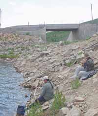
| Rick and Bonnie Valdez of Payson fish near the spillway at Scofield Reservoir last weekend. Scofield is not part of the Central Utah Project, but could still be impacted by the Gooseberry dam that was included in CUP plans. |
Water is an important commodity in Utah, particularly in the arid eastern region.
In the first issue of the Eastern Utah Telegraph – the first newspaper published in Price, the front page had a story about how wasted water could be utilized by a series of storage facilities.
Published Jan. 15, 1891, the article stated: “It is estimated that there are over 65,000 acres of land under cultivation in Emery County. We mean by this, land under ditch and well irrigated and an ample supply of water at all times. Water for four times this amount of land can be obtained from the running streams by building reservoirs in which to save it for future use, when it is not needed for irrigation, there being natural sites for them in the numerous canyons adjacent to the streams when the cost would be small.”
The support for damming streams to supply water came when resources in the area were first being developed. But at that time, few people realized what water would come to mean in the west in the next 100 years. They probably could not envision multi-state agreements like the Colorado River Compact. They had no way of knowing that concrete plugs would eventually create storage reservoirs to save water for municipal, industrial and agricultural uses at locations downstream.
Early residents could not be expected to recognize the powerful role water would play in the west during the 20th century. They could not imagine that conservative United States officials would fight construction of two Utah dams, while consortiums of small city electric utility companies rallied Congress to bring the projects to fruition in the 1960s.
Many Utahns felt that the Colorado River Basin was the state’s last large watering hole. The majority of Utah’s population was distanced from the large water resource. But the state was guaranteed more than 1.7 million acre feet of water per year when a bill was introduced into the U.S. Congress in 1946 to create a development scheme called the Central Utah Project . The purpose of CUP was to send “unused” water from the Uintah Basin and the eastern slope of the Wasatch Plateau through a series of reservoirs, streams and tunnels to the Wasatch Front. However, Congress and the president decided that another multi-state water plan was a better idea. CUP was subsequently incorporated in legislation in 1948 to create the Colorado River Storage Project for the upper basin states.
CUP originated in the minds of politicians and northern Utahns who looked at what the early pioneers had done by diverting water from the mountains and the work of two private concerns owned by farmers in Heber Valley that tapped into the resource in the Strawberry Valley for agricultural use.
On Oct. 22, 1948, the Upper Colorado River Compact was signed in Santa Fe, N.M., on the site where the original Colorado River agreement was inked in 1922. The action represented the beginning of CUP as an agency.
The project grew, finally resulting in seven units within the area of the CUP. Initially, the plan was to build two dams in Colorado. One was located on the Yampa River and the other on the small section that juts into northwest Colorado then flows back into Utah. There were also plans to construct a series of dams in the Uintah Basin and along the Wasatch Plateau as well as building canals, tunnels and aqueducts to move water to northern Utah for population growth and agriculture.
Two of the projects would directly affect eastern Utah. One was Joes Valley Reservoir which was finished in the mid-1960s to supply water to Emery County. The other was the proposed Gooseberry reservoir, which would divert water from the eastern drainage of the Wasatch Plateau into Sanpete County. While the Gooseberry was in the works at one time or another for 40 years before CUP was formed, the dam was envisioned to become part of the project in 1948.
But before any of the projects got off the ground, public opposition to the costs and questions regarding the benefits provided to American taxpayers began to surface.
Bogged down in pubic opinion, the efforts to move ahead with CUP were stymied to a greater degree by the Korean War, a time when money was diverted for the conflict the country was involved in, and away from public works projects.
But when the war was over, the public and conservationist opposition found strong supporters of the project in the form of the upper basin states political leaders as well as some grass roots pro-development organizations that were formed to get the CRSP projects started, with the CUP being the largest single unit in the overall project.
The two dams in Colorado never materialized. They were staunchly opposed by early environmentalists, including a group call the Living Rivers which was led by a man named David Brower.
Both dams were within the Dinosaur National Monument, so support from the general public for not building the dams was also much stronger in those areas.
The two dams actually built on the Green River in the 1960s were Flaming Gorge and Fontenelle Dam in Wyoming.
Living Rivers and other environmental groups are still opposed to these dams and are trying to get the Bureau of Reclamation to look at decommissioning both of them.
Since the dams in Colorado were not constructed, the first projects began in what is called the Vernal Unit of the CUP in 1959. The main dam holds the water of Steinaker Reservoir.
Finished in 1962, this reservoir provides water for the Ashley Valley.
Two other units are in the heart of the Uintah Basin. The Upalco Unit and the Jensen Unit, with Big Sand Wash Reservoir and Red Fleet Reservoir respectively, also provide water for the agricultural use of the basin.
But the unit considered the plum of the project, and the one that most who visualized it saw as being the most beneficial, was the Bonneville Unit of the project.
It was not only the center of the plan, but by far the largest and most expensive of any of the proposed units.
Work on this part of the CUP didn’t begin until 1967 with the first project being the creation of the earthen dam that created Starvation Reservoir, the first large reservoir and dam to be created within the project.
With that begun, the process then moved to the Strawberry Valley, where the small well know fishery, Strawberry Reservoir, was about to grow four times larger (in terms of water acreage) behind a new dam called Soldier Creek.
This project was built to directly take water that falls in the western part of the Uinta Mountains to the Wasatch Front. That project is still not finished, with the Diamond Fork Tunnel which will take water from Strawberry into Spanish Fork Canyon looking to be completed this fall.
Originally the water from the Diamond Fork system was to be at least partly used for southern Utah, Juab and Millard Counties. But recent events have changed that, and it now appears that most of that water will go to the north, particularly to the Salt Lake Valley, leaving those in the rural areas to the south out of the loop for water they had planned on for over 40 years.
The decisions to change where the water is going on this part of the project, along with other decisions over the years, have steeped the CUP in controversy since it’s creation.