On June 9, 1955, Everett Davis of Denver, Colo., died of injuries incurred in a automobile accident west of Wellington on U.S. Highway 6. The fatality occurred when a Helper resident, trying out a new Buick ran, head on into Davis’ car. The death was the first in Carbon County in 1955 and the first of the year on what residents in recent years have designated the “death highway.”
Davis died almost half way through the 1955 calendar year. In 2001, the first fatality on the highway took place in January and traffic deaths have continued to pile up month after month.
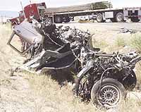
Castle Valley motorists know the dangers of driving on U.S. 6 between Green River and Spanish Fork. Most locals have been caught in some type of traffic jam on the road due to a mishap. And all residents have a story of at least one close call concerning traveling on the highway.
There has been many editorials written over the years in newspapers from Salt Lake to Moab about the situation. There have also been many angry letters written to the publications, the Utah Department of Transportation and government officials who directly or indirectly influence changes on the road.
Since the accident in 1951, traffic volume has increased on the road. Based on national statistics, it has at least doubled.
U.S. 6 is the designation for a road built early in the 20th century as part of the federal highway system, the precursor for the interstate highway complex erected from the 1950s through the present.
While people in Carbon County view U.S. 6 as a state road, the highway is part of the national road network. U.S. 6 begins its journey west on the east coast of the United States at the end of Cape Cod in Provincetown, Mass., and winds its way across the nation. Due to changes in the national system and interstate highways, parts of U.S. 6 have been usurped by the multi-lane roads, particularly by I-70 and I-76 in the west. But in some places in America, U.S. 6 still exists in basically the same form it did 80 years ago.
On its way west, U.S. 6 crosses many of the major cities of the country as well as many state capitols. After leaving Cape Cod, it crosses through Rhode Island and Providence. It enters Connecticut and passes through Hartford. West of Hartford, the highway has a nickname as it swings south – “the death miles.” This section of U.S. 6 is listed as one of the 10 worst sections of road in the United States. The road, coincidentally, joins Interstate 84 at its south end. One reason the section of U.S. 6 is so high in death statistics is the fact that people come off of I-84 and drive too fast north toward Hartford.
U.S. 6 breaks away from the tollway in Brewster, N.Y. The highway travels south and touches the New York City metropolitan area suburbs before crossing the Hudson River and traveling west. The road drops south into Pennsylvania, passes north of Scranton through rural Quaker country until it hits the Ohio state line and moves into Cleveland, where it travels along the south shore of Lake Erie. Near Port Clinton, Ohio, it starts to drop south and meets with I-80. Residents near the area call that section of the road the “death strip” due to vehicles high rate of speed coming off the interstate.
The road hits rural farm country, passing south of Toledo about 30 miles. The highway enters Indiana, passing north of Fort Wayne and south of South Bend when it eventually meets up with Gary, Ind., in a place where I-80 passes over it.
Chicago has basically swallowed up Gary, Ind., and the highway passes directly through the windy city’s suburbs as it touches the southern tip of Lake Michigan. This is where another section of the road that is known as one of the most dangerous stretches of highway in northern Indiana resides.
The road crosses the state line into Illinois, traveling through Joliet and flat farmland toward the Iowa border. U.S. 6 shadows I-80 almost all the way, serving as mains street for many small towns that were passed by when the Interstate system was built in the middle of the last century.
Once it enters Iowa, U.S. 6 becomes intermittent, breaking off of I-80 to travel through places like Iowa City and Grinnell, then branching away to pass through the middle of Des Moines. In western Iowa, it breaks off of the interstate and travels south to Atlantic, Iowa, one beef center of the Midwest. It proceeds into Council Bluffs, crosses the Missouri River and travels into Omaha, Neb.
From Omaha, the highway remains intact, traveling south to Lincoln then west through the cornfields toward Hastings and McCook. The journey across Nebraska ends when the highway travels unbroken into Colorado and ends at Fort Morgan, where it duties were relieved years ago by I-76.
U.S. 6 reappears west of Denver in various places, most notably near Eisenhower Tunnel. The road travels over Loveland Pass and where oversize loads or hazardous materials carriers must use the old highway to avoid tunnels forbidden to the cargos in question.
From there, I-70 has replaced U.S. 6 almost all the way to Green River, except for a small section in Grand Junction. The road heads northwest through Price and Helper, where it is officially designated U.S. 6-191, and proceeds on to Spanish Fork, where it is usurped by I-15 headed south.
U.S. 6 leaves the interstate system at Santaquin, heading west where it passes through Eureka and southwest to Delta. In Delta, it joins with U.S. 50 and becomes U.S. 6-50 across the dry west Utah desert crossing into Nevada. At Ely, the highways divide, with U.S. 50 heading north toward Austin and U.S. 6 moving southwest toward Tonopah.
U.S. 50 across Nevada has been named the loneliest highway in America. But U.S. 6 is almost as lonely as it passes north of the Nevada Test Site and the Site 51, used by the military for secret testing of equipment and aircraft.
The road crosses the California border and hits Benton, where itturns south.
Some Californians call U.S. 6 as it heads south to Bishop “a death road.” The highway has claimed a number of victims as people rush s toward the dual national parks west of Bishop, Kings Canyon and Sequoia.
At Bishop, U.S. 6 joins with Highway 395, a sometimes two- to four-lane road and at other times a freeway. U.S. 6 ends after wandering through the plains, mountains and deserts of the U.S. for slightly more than 2,000 miles.
Within the 2,000 plus miles, there are at least four places where the highway is considered a death generator by the public due to design or driver error or both .
The number of deaths that have occurred on the entire length of U.S. 6 would be difficult to determine. But the fatalities occurring on the local strip between Spanish Fork and I-70 are monitored by UDOT.
According to the available statistics, there have been 100 deaths on the road between 1996 to 2000.
In 1996, five people died. But the following year, 23 were killed on the stretch between Spanish Fork and Green River.
During the two-year period from 1999 to 2000, the number of related deaths have registered at 13 and 17 respectively.
Have changes on the highway, such as additional passing lanes and signage, been responsible for the small drop in fatalities since 1998, when 22 people died?
What about the future?
How will the highway change to accommodate the anticipated increased traffic loads traveling on U.S. 6?
“Our engineers try to build roads that will serve populations at least 30 years in the future,” indicates Myron Lee, region 4 public information for UDOT. “It’s hard to exactly predict what will happen, but they try to do that.”
While UDOT investigates every traffic death on U.S. to see what can be done to improve the road and prevent more fatalities, the responsibility for safe roads is a joint one.
That responsibility is split between the public departments taking care of the highways and enforcing the laws and the private motorists who use the byways.
The public and private sectors share an important charge when it comes to improving conditions and reducing traffic safety concerns for people traveling on U.S. Highway 6.
U.S. 6 Labeled ‘death Highway’ at Several Sites in Nation