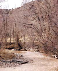
| Water rushes around a bend in the Price River. But the scene could be misleading since spring runoff in the local drainage basin is expected to be lower than last year and register below average. As of March 1, the Price River drainage basin is showing 57 percent of last year’s snowpack and 55 percent of average. |
Spring water runoff in the Price River drainage basin and at locations across the rest of the state is expected to be somewhat lower than last year and register below average.
As of March 1, Price River drainage basin is showing 57 percent of last year’s snowpack and 55 percent of average.
The San Rafael River basin is faring slightly better than the Carbon County area.
The current snowpack levels in the San Rafael drainage basin register at 60 percent of last year and 62 percent of average.
Across the southeast region, including Carbon, Emery, Wayne, Grand and San Juan counties, snowpack figures are lower than last year and lower than normal.
“Snowpacks in this region are much below normal at 60 percent of average, about 72 percent of last year,” indicated the latest snowpack telemetry (SNOTEL) report generated by the United States Natural Resources Conservation Service.
For the region to get to average snowpack, March would need to experience an unprecedented 303 percent increase.
And while getting back up to normal levels is not likely in the foreseeable future, the Price River drainage basin is up from Feb. 1, when SNOTEL reported levels at 39 percent compared to last year and 44 percent of average.
Despite the increase, the Price River basin’s figures remain lower than the rest of Utah.
Statewide, the snowpack levels register at 71 percent of average.
The March SNOTEL report estimates less than a 14 percent change of meeting average snowpack in March.
And while the Price River drainage basin and other areas of southeastern Utah are showing lower than average snowpack levels, there are other areas of the state which are further below average.
In eastern Garfield, Kane, Washington and Iron counties, snowpack is 59 percent of average.
But the good news in the four counties is that snow levels in the region are up 138 percent from last year.
The region in the best shape for snowpack is the Uintah Basin, where snowpack levels still only reach 78 percent of average and 77 percent of last year’s figures.
But while snowpack is down sharply from last year, precipitation is closer to average levels.
Southeastern Utah shows precipitation at 96 percent of average.
Statewide seasonal accumulation is 88 percent of normal, with lower levels in the Bear River area at 83 percent.
But even with higher precipitation and higher water levels in Scofield, it’s not likely that 2007 will finish off as a high water year.
“March needs to be big to take the sting out of this season,” stated the March SNOTEL report.
But even with very low snowpack levels and slightly below average precipitation, storage reservoirs are showing more positive figures.
“General water supply conditions range from below average to much above average,” indicated the SNOTEL report.
Restrictions on Scofield Reservoir remain in effect for the third year in a row.
Originally designed to store more than 65,000 acre feet of water, the U.S. Bureau of Water Resources has restricted the reservoir’s capacity to 54,500 acre feet.
The 30-year average usable storage for the reservoir is 34,800 acre feet.
At the end of February, Scofield contained 37,600 acre feet of usable storage. That’s up from last year at the same time, when the reservoir contained 37,200 acre feet of usable water.
Higher water levels are due partly to lower release levels.
According to the data compiled by the U.S. Bureau of Reclamation, water release at Scofield dam was cut in half from 10 cubic feet per second on Feb. 8.
On Feb. 22, the release of water from the dam at Scofield was closed entirely.
Officially, the dam is currently releasing no water. Any water released from Scofield Reservoir is due to structural leaks.
And while the dam is releasing very little water downstream, levels in the reservoir have been steadily increasing.
Since March 1, the intake of water flowing into Socfield Reservoir has averaged almost nine cubic feet per second.

