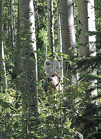
| A rider on a horse cuts through the trees on a warm July day. Gordon Creek Canyon shows it’s colors no matter what the season. |
On a hot summer day the water runs down the creek through the flowers and into grassy meadows before it empties out into the stark desert below.
In the fall the blue skies punctuated by puffy white clouds stand out above the yellow and red leaves.
This is upper Gordon Creek or more to the point the south fork of Gordon Creek in Bob Wright Canyon. It is a place many haven’t seen.
To most people in Carbon County, Gordon Creek is a road or a deep severe wash that runs through the western part of the valley until it connects to the Price River.
But there is another place, high up near the Wasatch Plateau where the water runs clear and the aspen, pine and oak trees cover the ground.
It is a place for hikers and horseback riders, and those looking for a quiet afternoon away from the heat of the valley or those who want to see the color of the leaves.
| Oak leaves are a deep orange as autumn colors pigment the area. |
It is a canyon of four seasons and all are beautiful. The only problem is that it is hard to get to it during the winter because of the deep snow. And that snow brings on roads that are full of mud in the spring. But in the summer and fall, it is as beautiful as anywhere on earth.
Bob Wright Canyon can be accessed by turning from U.S. Highway 6 onto Consumers Road and heading past the Wildcat Loadout. A steep left hand turnoff, unmarked but called Benches Road about 9.5 miles from the Highway 6 and not far east of the Horizon Mine takes drivers down into a gully where it crosses the north fork of Gordon Creek. The road passes over the creek and then zooms back up the other side of the canyon where a flat is found that heads toward the southwest. The road twists and turns past a gas compression station and into the valley where the Gordon Creek Wildlife Management area is located. Vehicles then travel along the north side of the fence and toward the west as they approach the canyon. The road is marked by a restricted vehicle sign that in the summer is surrounded by Larkspur and in the mid-fall sits in the middle of some of the most beautiful oak leaves in the county.
Past the sign the road rambles past the wash that has been created by the creek and then it turns to go east again. At this point there are two roads that cut up Bob Wright Canyon. The first takes vehicles up a side canyon. The second, that has a Y junction takes drivers into the heart of the bottom of the canyon. This turnoff is about six miles from the Consumer Road junction.
Once there vehicles can park in a grassy meadow surrounded by pine and aspen.
| The yellows. browns and greens of lichens and moss cover a rock surrounded by dense undergrowth. |
While where the vehicles can park is beautiful, a short walk up the road will prove even more spectactular with the views of the cliffs and the wonderful stream that flows through it.
Immediately the road crosses the stream and in high water months feet are almost bound to get wet. The water is cold and clear.
A short walk provides a vista of aspen and pine piled up above a road cut and then it heads up the canyon. Along the way it is impossible not to notice the flowers in the summer and the bright colors in the fall.
A mile walk puts a hiker in a meadow with a landmark rock that points the way up to the upper reaches of the canyon. Others have been here, the stone has the names “Scott and Sue” carved into it separated by a heart. This is a good place to rest and drink some water before the climb continues.
Once it does the path continues into heavy forest and the stream runs far beneath the hiker in a gulch at the bottom of the canyon. The trail has a lot of tree falls across it at this point and getting horses into the area requires a little effort. Soon however the trail degenerates into a track along the side of a hill with a lot of growth. Hikers should be prepared to work their way around fallen logs and growth that blocks the way while having their footing on a 45 degree grade.
Once past this the trail is much less clear. Near this area are the remmants of a shack of some sort, but the only thing left are afew rotted boards with some moss growning on them, and the observer has to look to find these.
The trip back down the canyon is just as enjoyable as on the way up. The vistas that open up of cliffs, trees and mountains are spectacular.
This is a place where generally peace can be found, mostly away from engines, other than the sound of passing jet liners.
This area is administered in part by the Bureau of Land Management and part by the Manti-Lasal National Forest. All regulations for off road vehicle travel count here.
It is easy to count that this area looks much like it did (with the exception of a couple of road cuts) when the navtive Americans roamed the county.
For the hiker, backpacker or horseman, it is a day in that most elusive place called paradise.

