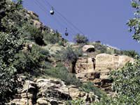
| Hanging from cables and wooden supports installed across the rugged terrain and rocky cliffs near Bruin Point, gondolas are the remains of past attempts to extract tar sands from the Nine Mile Canyon area. |
As officials have planned a proposed multi-use route through Carbon County, officials have worked to connect the existing trails that are established throughout the local area.
As the route hits East Carbon and Sunnyside, the goal of connecting to the cities is likely to be completed. However, the route doesn’t stop there.
Recognizing the increased interest in Nine Mile Canyon, county planners have suggested that the route continue past Sunnyside for a loop that would be purely touristic in nature.
As the route leaves Utah Highway 123, it heads up Whitmore Canyon. Just before the paved road ends, the trail cuts left on Bruin Point Road.
The canyon that the road follows is Water Canyon.
As trail users enter Water Canyon, one of the first points of interest will likely be the cables above them.
The gondolas still hanging from the cables and the wooden support structures are the remains of attempts to extract tar sands from the cliffs high in the canyon.
As the road winds up the canyon walls, it crosses the cable lines.
At times, the road comes within a few feet of the decaying wood frames supporting the cable lines.
The road up to Bruin Point has been improved by the county. Though pitted with ditches and littered with rocks, the road is fairly well maintained.
However, the route is steep. This makes it impassible by most highway vehicles. Only high clearance vehicles with four-wheel drive can make it over the pass. The road is perfect for ATVs and horses.
As the road approaches the summit of the pass over Bruin Point, it reaches the highest elevation of the trail.
Bruin Point sits at more than 10,131 feet above sea level.
| Communications towers mark the highest point of the route, Bruin Point, climbing to an elevation of 10,131 feet. From here, trail users can see from the Green River to Castle Dale. |
The point is marked by a number of radio towers. Signs at the bases of structures tell passersby the purpose of the towers.
Some of the towers are used by the United States Federal Aviation Administration. Others are for telephone and television.
This is the highest point of the Roan Cliffs. To the east, trail users can see to the Green River and beyond. To the south, the trail overlooks the Castle Valley. On a clear day, visitors to the point can overlook the north end of the San Rafael Swell and see the smoke stacks of the Hunter Power Plant near Castle Dale.
At Bruin Point, the trail splits. One route heads down Dry Canyon. The other heads down a lesser known Jeep trail.
Bruin point is above the timberline. Almost devoid of trees, the point is littered with sage brush and grasses.
But as the trail descends down the back side of the point, trail uses are back into densely forested hillsides. These north-east facing slopes are still spotted with snow in early July.
The route down Dry Canyon is impassible right now because of downed trees. A wet winter and spring has let a number of the quaking aspens and Douglas firs fall across the roadway.
After the route down Dry Canyon drops below 8,000 feet, the road follows Dry Creek. The canyon bottom widens and continues its slow descent.
As the road approaches Nine Mile Canyon, petroglyphs on the canyon walls remind trail users that this route may have been used more than a thousand years ago by Fremont Indians.
The route hits Nine Mile Canyon near The Mummy. More petroglyphs welcome trail users along Nine Mile Canyon Road. One set is on the north wall of the canyon, opposite the junction with Dry Canyon.
On Nine Mile Canyon Road, the trail continues east to Cottonwood Canyon. At the mouth of the canyon, two more sets of petroglyphs are visible on the west wall of the canyon.
The route veers out of Cottonwood Canyon and heads up Twin Hollow. A steep road out of the hollow takes trail users past a straight section of road that is wide enough and long enough to be used by small planes as a landing strip.
After the landing strip the route is mostly level until flat iron mesa takes the route to an elevation of almost 9,000 feet.
A Jeep trail and a steep grade back up the canyon wall takes the trail back up to Bruin Point, passing the radio towers and joining back up with the route over Bruin Point.
The total distance of the loop from Bruin Point, down Dry Canyon and back up Cottonwood Canyon is just over 42 miles.

