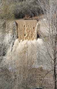
| The Price River pushes waves of muddy water over the brick spillway near the golf course. The spring runoff from the mountains has started in earnest as the temperatures in the valley near the 70 degree mark. |
Last year, heavy snows falling in Castle Valley led Carbon County residents into thinking that the six-year drought had ended.
However, the winter storms in the valleys did not translate into heavier snow in the high country.
In addition, the ground was thirsty from years of moisture depletion and a warm March sent snowpack plummeting downward too fast.
But it appears that the drought may have ended.
The winter began with heavy rains which soaked the ground and the storms were followed by heavy snow, filling the mountains in the Carbon County drainage to levels not witnessed since 1997.
Recent statistics from the Snowtel website show that the main drainages feeding the Carbon County area are in good shape water wise.
The current amount of water equivalent in the White River drainage measures at 16.3 inches.
The current level is 135 percent higher than the 12.9 inches normally measured the same time of year.
In the Mammoth-Cottonwood drainage, the 21.7 inches of water present in the snow pack registers as 116 percent of normal.
Mammoth-Cottonwood is the watershed for Scofield Reservoir, the main supplier for western and central Carbon County.
The drainages in some parts of Utah are measuring at 270 percent of normal.
In the Sevier River drainage, which runs from Hatch through Richfield into Yuba Lake, the average daily flow from May through July is expected to be 20 percent to 30 percent higher than the normal high water mark for the period.
The situation could mean flooding in the Sevier River area.
The Virgin River drainage in Washington and Kane County may experience the worst flooding in Utah because of high snowpack and moisture laden ground.
| Warming temperatures produce spring runoff flows along the Price River channel near Castle Gate. Drainages feeding the river and Scofield Reservoir have exceeded average annual levels in 2005. |
For Carbon County, flooding would probably only occur in isolated areas if the heat increases quickly.
In the past few years, canal companies in the Carbon County area have been supplying less water per share due to ongoing shortages affecting supplies.
Last year, only 50 percent of the water per share was delivered to most area users.
However, water experts continue to question whether Scofield Reservoir will fill up in 2005.
“Our water situation this year is much better than it has been in some time,” said Mark Page during a telephone interview on Wednesday. “But I still don’t know if what we have will fill up Scofield.”
Some estimates predict that the 65,000 acre foot reservoir will top at 50,000 acre feet in 2005.
But Page indicated that the warmup pattern in the spring will determine a lot of what water will be available.
The warming pattern is also important to residents who have shares in canal systems in the county, particularly the individuals with direct flow rights.
A share is equivalent to an acre foot of water or one acre of land covered by one foot of water.
A share is also what people must turn into the Price River Water Improvement District in order to obtain a building permit to construct a home in the county.
PRWID has continued to buy shares annually in an attempt to ward of the decreasing water value of the district’s shares.
According to PRWID officials, the district has purchased the shares in order to continue to suppl municipal and industrial users the water needed even in the time of drought.
Last year, 94,455 acre feet of water was allocated to users in the Carbon County area, according to a report completed by Bob Davis, the dam commissioner at Scofield. The total amount of allocated water was divided between direct flow and reservoir rights.
Direct flow rights involve water running down Price River from the drainage that has not been captured by a dam. Reservoir rights involve water released from Scofield.
The largest user in the local area last year was the Carbon Canal Company with 19,191 acre feet of water. Next was the Price Wellington Canal Company with 14,901 acre feet.
As for municipalities, Price city used the most with 2,202.20 acre feet. PRWID used 1,722.93 while Helper took 421.80. The municipal and industrial total last year registered at 6,708.90 acre feet. The largest non-water distributing consumer in Carbon County was PacifiCorp at 2,298 acre feet.