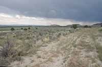
| Several roads crisscross the property county officials purchased on Wattis Road for a new gun range/recreation area. Primarily used to serve gas wells in the area, the roads have been documented by county personnel so planning can start on the recreational project on the property. |
Property on which to build a county gun range was hard to find until July when the Carbon County Commission approved the purchase of a parcel of land near Wattis Road. The purchase was finalized last week when the papers with the previous owners, Frank and Carol Feichko, were signed.
Now the architect for the range, which has evolved into a recreation area, has been selected, He was at the county commission meeting last week to let the commissioners and the gun committee know that he is ready to go to work.
“I have looked at the site and I see many possibilities in the various areas of the land,” said Art Pasker of the firm of Pasker, Gould, Ames and Weaver of Murray. “Actually, it is a good fit for many of the things the county has ideas for. I think the site work will be minimal.”
In June the county commission and the gun range committee were feeling heat from the Community Impact Board about money that had been released to the county almost a year and a half ago to develop a gun range. The $750,000 grant and a $750,000 low interest loan were in jeopardy if they couldn’t find a place to use it.
Initially, proponents of the project thought about planning an indoor range near the county fairgrounds.
But after visiting a number of facilities at locations around the country, the proponents found indoor ranges were difficult to run and expensive to maintain.
Therefore, the groups supporting the project decided to move toward the concept of an outdoor gunrange.
During the next year, the officials spent time concentrating on two sites. One was United States Bureau of Land Management ground near the Carbon County Airport. The other was near Pinnacle Peak, ground which belonged to the State Institutional Land Trust.
The BLM process fell through after a lot of work and scrutiny, primarily because of concerns about its proximity to air space at the airport as well as the amount of time it would take for the BLM to be able to release the property to the county.
Costs of improvements and utility placement were also concerns.
Comparatively, the other site on public land was only a flash in the pan when it became apparent that SITLA and the county could not work out a deal on the other piece southwest of Price that is dotted extensively with gas well sites.
The problem then became finding private land that would work within budget, as well as what was required for such a venture.
First, local officials had to find the right amount of property (about 640 acres) in a topographical configuration that could be used.
Second, the land would have to be in the right place so the site would be convenient for users of the range. The property would also have to be available for the amount of money the county had to purchase the land.
So, the committee and the commission began searching for private land. Things looked bleak as land leads and offers of possible sites ran through the proponents’ hands like sand. Just as the members of the groups were beginning to doubt they could find a place to put county gun range, things changed.
“Everyone was working to find a good place for the range,” said County Commissioner Steve Burge. “This place, when presented to us, was exactly what we needed.”
The final price for the 640 acre parcel was $300,000.
The purchased property is located several miles up Wattis Road from its junction with Hiawatha Road. Besides general and specific gun venues, there will be room for archery and paint ball ranges. The land has water on it that comes with the property that emanates from North Springs. The property has a right to 16 acre feet from that source. While not of culinary quality, the water could be used for irrigation of landscaping around a proposed clubhouse and camping grounds at the site, according to officials.
There are also some ponds that have been created by the springs, and there is the possibility of a fishing area being created out of those ponds or in another spot.
In addition, on the southeast side of the property there is a perfect place to build a “rock crawler” course. The county has been trying to find a place to put the venue for about a year.
Probably some of the most attractive values of the property is its location.
Only 20 minutes from Price, it has a good highway that leads right up to it and the existing gravel roads are in good shape, although the county will probably close some of those off and design a new road system that better fits the need of the area.
The main part of the property sits at about 6,300 feet in altitude, which makes it a little cooler during the summer months than different location at the bottom of the valley.
A large flat in the middle of the land seems perfect for the long distance shooting ranges and has about a 3 percent grade from east to west.
“Based on what I have seen we will have lots of concrete work to do,” said Pasker. “I will also need to work with a civil engineer on some of the grades of the property.”
Existing roads that lead to gas wells on the property have now been geographically positioned and an overlay has been done to match the real roads with the maps.
The position of those roads was a concern in a previous meeting because county officials were worried that wells and roads could get in the way of developing the recreation area. However that all seems to have been resolved.
“I’m not sure how many roads we’ll need to build but I know the county will do some of the work on those themselves,” said Pasker.
Proponents of the recreation area have said they could envision someone loading up their various firearms, a fishing pole and other gear and spending the day driving from spot to spot on four wheelers or golf carts and participating in many of the different venues offered.
The commissioners then discussed that a master plan should be developed and then the work can go on from there. Pasker suggested that he needed to work closely with the leaders of the gun range committee.
“I just want to be sure we get the correct shooting areas on the right sites,” he said. “Based on what I have seen, this is a great site on which to build this venue.”
After his comments Pasker had an extended meeting with the gun committee in a small conference room and began to work out the details on the building of the range.
The commission agreed to pay Pasker $5,000 for the work he has already done on the range. His commission on the project will be 5.25 percent of the construction cost.
The commission also appointed the architects for the new county road shop that will be built on Airport Road. The firm is the same one that was selected to design the new Carbon County Ambulance Garage, Edwards and Daniels of Salt Lake.
In other business, the commission approved a Memorandum of Understanding (MOU) with the BLM on a gate to be placed across the road that goes up Jacks Canyon, near the Nine Mile Canyon area.
The road was originally built in 1976 for oil and gas development and it leads to a wilderness study area which also has some ancient rock art sites on it. The BLM has said that, in recent years, vehicles have been going off the road into the WSA and that people have also done some damage to the rock art as well as some digging for artifacts in the area. The gate would control who goes into the area in or on vehicles. The MOU has to be presented to the BLM so the federal agency can review and accept or reject the plan.