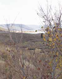
| Looking toward the North end of Scofield Reservoir, Bolotas subdivision, set in the middle of the scrub oak, on the edge of the lake, looks serene and peaceful. However for the last 40 years many battles have raged between property owners because of property line disputes. With recent work done by the county, now those disputes may be a thing of the past. |
For years, problems with property lines in the Bolotas subdivision on the east side of Scofield Reservoir have plagued residents, Carbon County’s planning and zoning department and finance and mortgage companies working with owners and buyers in the area.
But after settlement work last fall, through the efforts of the county planning and engineering departments, the Carbon commission and area residents, it appeared there were only a couple of roadblocks left to remedy the problem of corrupt property lines.
One roadblock was overcome last week when county officials received a letter from Professional Title Services.
The company was asked to check to make sure the original piece of property parted out by the Bolotas family in the early 1960s to set up a subdivision near Scofield was properly owned by the initial project developers.
“When I saw that letter, I breathed a sigh of relief,” said county building and planning director Dave Levanger.
The letter referred to a transfer of land in 1952 in which the entire area being checked out by the title company was conveyed to Arthur Bolotas by Neil and Andrew Madsen.
Almost 10 years later ,the Bolotas family started parceling out land to people for a subdivision.
But the subdividing process was reportedly done inappropriately and, since then, property lines and titles in the area have been the subject of disputes.
Now, with the title research completed, it appears some solutions can be found.
The company’s letter related the fact that “… It appears from this research that we will be able to continue to insure the fee simple title or individual lot owners within said lands.”
Levanger also explained that another problem that related to determining the proper boundaries has been resolved by the county as well.
At a county commission meeting last fall it was discussed that two section corners, which surveyors work off to set property lines, had been installed in the last 40 years.
One was done about the time the subdivision was set up.
The other had been done recently by the Bureau of Land Management at the request of the Bureau of Reclamation (BOR). According to the official the county will be using the older marker.
But even more importantly is the fact that the BOR may be backing off, claiming a higher water mark on the reservoir than they were claiming last year.
Last summer they claimed that the high water mark they have set for the reservoir was 16 feet above what the county believed it to be.
Their figure of 7632 (the level of the top of the dam) could have meant that much of the area on that northeast section of Scofield Reservoir where people had built structures over the years, could have been claimed by the BOR as a flood plain.
While nothing official about that situation has come from the BOR, Professional Title Company met with a representative from the agency during the process of evaluating the property, and they were told by the BOR real estate manager that as far as he was concerned the company could verify that the properties could be given clear titles for ownership purposes if they legally meet those parameters.
“With that it appears that the flood plain issue may be resolved,” stated Levanger. “Now we can begin to work with the rest of the residents in the subdivision to solve these boundary problems.”
Initially the negotiations on this situation were done with the eight property owners that had lots along the lake and the individual who owns all the common areas in the subdivision.
The subdivision is private and the county does not own nor maintain property there.
“Now we can approach others in the subdivision about determining permanent property lines between their properties,” explained Levanger.