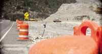
| Construction on U.S. Highway 6 continues west of Tucker. In the past, work on the highway has ranged from minor repairs to major reworks of certain parts of the road. One of the biggest projects was begun with the planning stage in 1961 when a total revamp of the portion of the road through Price Canyon was started. The initial construction phase encountered several delays and the actual highway improvement project wasn’t completed until 1966. |
The year of 1966 was an important one in the history of Carbon County. Many of the leading local stories of that year have had lasting impacts on the area.
Major events included the installation and first operation of natural gas in the Price area, the opening of Sally Mauro School, replacing the Helper Central School which burned down a couple of years before and the completion of the music building on the College of Eastern Utah campus.
At the same time, officials were building the science center and new physical-heat plant as well as planning the new library at CEU.
In more celebratory terms was the 50th anniversary of the building of the Greek Church on 100 South and 300 East in Price.
On the dark side were the deaths of five members of one family in a car accident on U.S. Highway 6 near Woodside and another wreck in which three were killed near the Sunnyside Junction.
The U.S. 6 problem had risen its head again, just like in 1925, 1937 and 1956.
The road had been a killer and, even though many of the fatalities occurred on the way from Price to Green River and from Colton to Spanish Fork, most residents considered Price Canyon to be the most deadly.
Statistically, the assumption was not true. But when politics and emotion entered into the formula, it was perceived that way.
The winding road from Castle Gate to Colton had taken its toll of lives during the years and, particularly in bad weather, the section of highway was something people preferred not to face.
In 1966 after almost two years of construction and 10 years of planning, the road that still resembled the Midland Trail highway that had opened in 1913, was replaced by a modern highway. The road was wider, safer and better built with fewer drop offs and less curves.
The idea for a new highway to replace the old U.S. 6 began not long after traffic started to pick up following World War II.
America was on the road; two cars, even three per family were becoming common place.
Rail travel was decreasing while air and automobile transportation modes were exploding.
Cars were able to cruise at high speeds much more comfortably. Air conditioning, power steering and brakes and 300 horsepower V-8 engines made by Detroit leveled out the mountains, hills and curves.
Yet safety was not a big deal to the majority of Americans, unless they were members of one of the 50,000 families each year who lost loved ones to an automobile accident.
In 1956, Ford Motor Company had to compete with other vehicle manufacturers in the horsepower wars.
Ford also introduced several notable safety changes that officials thought would make the company’s cars sell better.
Two of the changes included optional padded dash boards and safety belts as standard equipment.
Ford almost lost the boat on that one. Americans wanted little part of safety in their cars and they certainly didn’t want to pay for it.
But they did want safer highways. While freeways and expressways were common in many states, the interstate system was just being built.
In the case of southeastern Utah it would be almost two decades before I-70 would slice through the San Rafael Reef and traverse the swell, completing that highway from Cedar Fort to Baltimore, Md. Until that time people would have basically two choices to get to Las Vegas and Los Angeles once on I-70: U.S. 6 or Salina Canyon.
In early 1961 the Utah Road Commission (predecessor of the Utah Department of Transportation) decided it was time and began to work on plans. But to change the ten to 12 mile section through Price Canyon would require major money and major preparation. Remember, there were few alternate routes and traffic was increasing dramatically each year. So the very thing that was causing the need for a better road was actually holding up the construction; an alternate detour would be needed during what they assumed would be a three year construction plan.
The U.S. Bureau of Public Roads agreed to help with funding, but only if the new highway was completed before the detour wore out. The state had to promise to pay rehabilitation costs of the detour should the project take so long that the detour became unusable.
In retrospect, that being one of the sticking points, seems today to be ridiculous. The detour that was built is what we know as today as the Kyune Pass Road ( what Utah County calls it) or Emma Park Road (the name Carbon County has designated for it). While it did exist, it needed major improvement so it could handle the traffic it would face over the next few years. It’s a road Carbon County residents have used for years when there is an accident in Price Canyon or other construction is going on, and it also a major access to some gas wells in the area of Emma Park.
The estimated cost of building the by pass road was $480,000 in 1961. But the cost of reconstructing the canyon road was almost $5 million. The state could get 4.5 million, but had to come up with the rest. But the committed to it and the process began.
One of the expenditures to widen and straighten out the highway in the canyon was to buy property from two coal companies to do so; the Royal Coal Company and the Independent Coal Company.
On June 30, 1961 it was announced in the Sun Advocate that the detour road was being designed and that construction would on the new highway would probably begin by late 1962.
In late 1961, the bid to improve the Emma Park Road was given to W.W. Clyde of Springville for a bid of $428,000.
Up unto that time at least 3-4 deaths would occur a year on the canyon road that was being replaced, some years many more. People feared that the detour would cause more during the construction period, largely because of much narrower and winding Willow Creek Canyon and the lulling flats of the Emma Park route that could get people driving too fast.
But this was considered superior, not only in safety, but also in the speed of finishing the project to trying to route traffic through a construction zone in the narrow corridors available.
But as with many construction projects, things just didn’t happen as quickly as people wanted. And to add to that consternation, a large road project, fixing many problems in Spanish Fork Canyon, including some big work in the Red Narrows was already underway in November of 1961, making eastern Utahns feel like the neglected cousins once again.
But the change did come. However, it would be another five years before Governor Calvin Rampton would be at Castle Gate cutting the ribbon to officially open the new highway through Price Canyon.