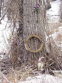
| A memorial marks the place where a motorist died on U.S. Highway 6 in Price Canyon. People may confuse overall auto death statistics with U.S. 6 numbers and some think all of the fatalities on the road happen in Carbon County. According to the data, the number of U.S. 6 fatalities occurring in the county has not really grown in the last 50 years, despite heavier traffic demands. |
The Utah Department of Transportation’s public comment planning meetings are concluded.
And as UDOT sifts through all the input the public offered, it is important to note that the effort the state agency is making to improve U.S. Highway 6 has not diminished.
On Tuesday, UDOT officials announced that the department will start constructing passing lanes on U.S. 6 between mileposts 196 and 201 in Spanish Fork Canyon.
In terms of travel, that relates to the area east of the construction done near Sheep Creek Junction last year to near where the bridge crosses the railroad tracks west of Tucker.
Past improvements have increased the traffic capacity of the highway, which is needed since there has been mounting demand placed on the road in the last 50 years.
The improvements make the highway safer, as well.
People may not realize how the road has improved during the years, largely because of the seemingly high accident and death toll rate on the highway.
Facts may also get mixed up with fiction and geography may be confused in the process.
Statistics can sometimes be misleading – not outwardly, but by the way the data are interpreted.
For example, it is not unusual for an individual to hear about a fatal accident in eastern Utah and count the traffic death toward the legacy of U.S. 6. But fatal accidents happen and have happened across the region on many different highways.
Another misinterpretation comes from counting statistics for the highway from the time it leaves Interstate 15 to when it joins with I-70 as being Carbon County data.
Admittedly, some accidents occurring outside of the local boundaries involve people from Carbon, Emery and Grand counties.
But the whole load for how bad or good the road is should not be put on Carbon alone, even though the geographical region anchors the highway.
The state road department and public entities began keeping actual statistics on the highway in 1933-34.
Some sketchy data exist before 1933-34, but since that time the handle on the situation has grown year by year.
When people sort through old newspapers from the 1930s and 1940s, it becomes apparent that accident and death rates within Carbon County were high, even though the traffic was a small percentage of the present demand.
The situation was probably due to poorer road conditions, autos that were much less safe and less restrictive traffic rules.
Beginning in the late 1940s, safety became a bigger issue as cars became more powerful and traffic started to increase.
Almost every edition of the Sun Advocate carried a report of some type of new road safety program or informational article on how to drive defensively.
But many of the deaths that took place during that time period, in fact the majority, did not happen on U.S. 6-50.
In some years, the majority took place on other roads and surface streets in towns and cities in the county.
But the highway was still a problem. Most accidents had nothing to do with substandard road conditions, but high speeds and poor decision making – the same kinds of actions that create the dangerous situations today.
At the time, the highway was the main route for people traveling west through central Colorado. There was no I-70 slicing its way through the San Rafael Reef.
For the Carbon area and roads within the county, the death tolls looked like this:
| 1951 | 5 fatalities |
| 1952 | 7 fatalities |
| 1953 | 6 fatalities |
| 1954 | 8 fatalities |
| 1955 | 5 fatalities |
| 1956 | 9 fatalities |
| 1957 | 1 fatality |
| 1958 | 3 fatalities |
| 1959 | 2 fatalities |
| 1960 | 3 fatalities |
| 1961 | 11 fatalities |
The death toll went up and down quite consistently during the 10-year period, with the most fatalities occurring around the time that the road through Price Canyon (early 1960s) was reconstructed to configure what is currently in place.
The rundown on the death toll within the county reveals interesting information.
In the early 1950s, numerous fatalities took place off of Highway 6.
Examples include the death of a mother near Columbia who fell out of a car while allowing her child to steer the automobile and three teenagers killed within Price city limits in 1956 when the vehicle they were in hit a tree at high speed on Railroad Avenue.
As the decade progressed, however, more of the deaths seemed to occur on U.S. 6. By 1961, the highest toll within the county in the decade, eight of the 11 fatalities occurring within Carbon’s boundaries were on the highway.
One victim was killed in February in Cat Canyon, then two died in a head on traveling on what is today Carbonville Road.
The intersection near the Old Wellington Road claimed a man who was standing talking to a driver he had an accident with in July. And three people were killed when the car they were traveling in had a head on collision with another vehicle about halfway between Wellington and the east Price city limits.
Finally, another man was killed in December when his car plunged off a cliff in Price Canyon.
According to milepost statistics, 20 people died in 1998 on U.S. 6 between Spanish Fork and Green River. However, only eight of the traffic accident victims died within the geographic boundaries of Carbon County.
In 1999, a total of 10 people died in traffic accidents on U.S. Highway 6, with six of the fatalities occurring within the geographic confines of Carbon County.
In 2000, eight victims died on the highway in the surrounding area, with three of the fatals happening within the county’s boundaries.
If the newer statistics compiled for U.S. 6 are compared to the older data, the rate of fatalities occurring within the county on the road is near to the same, even with the heavier traffic load.
But the traffic mishap data do not change the fact that deaths occur and one fatality is too many.
It also brings to light the fact that, with the improved safety of the roadway and the cars people drive, rates compared to heavier traffic flow can be reduced.
The Utah Department of Transportation plans to continue to try and improve the highway with projects, such as the one slated to be underway this week.
According to officials at the state transportation department, road cews were scheduled to start preparing the designated area for excavation work on April 11.
Completing the preparation work on the roadway is expected to continue for the next few days, which will cause minor traffic delays on the stretch of U.S. 6.
However, once full construction work begins, motorists should expect narrower lanes and light to moderate travel delays between 6 a.m. and 7 p.m. Signs will be posted and flaggers in place to move traffic through the construction area.
Because of air quality restrictions in Utah County, the U.S. 6 improvement project could not becompleted without obtaining approval from the Environmental Protection Agency (EPA) and the Federal Highway Administration.
The EPA and the United States highway administration granted the federal agencies’ approval for the roadway improvements in May 2001.
The construction work on the segment of U.S. 6 should be substantially complete by Oct. 31, indicated the Utah Department of Transportation.